Heshui geodata
Heshui (Hunan) is a seat of a fourth-order administrative division; located in China in Asia/Shanghai (GMT+8) time zone. With population of 650 people, there are 1241 cities with bigger population in this country. Compared to other cities in China, 74.3% of cities are located further ↑North; 71.6% of cities are located further →East and 56.9% of cities have lower elevation than Heshui. Note1


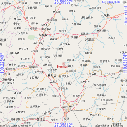
Heshui GPS coordinates[2]
27° 58' 50.988" North, 109° 55' 42.996" East
| Map corner | latitude | longitude |
|---|---|---|
| Upper-left | 28.59997°, | 109.22549° |
| Center: | 27.98083°, | 109.92861° |
| Lower-right: | 27.35812°, | 110.63174° |
| Map W x H: | 138.1×138.1 km | = 85.8×85.8mi |
| max Lat: | 53.31946° ⇑74.3% North |
| Heshui: | 27.98083° |
| min Lat: | ⇓25.7% South 18.22056° |
| min Long | Heshui | max Long |
| 75.07348° | 109.92861° | 134.28917° |
| W 28.4%⇐ | ⇒71.6% E |
Elevation
Elevation of Heshui is 225 m = 738 ft, and this is 259.8 m = 852 ft below average elevation for this country.
| Max E: |
5622 m = 18445 ft | 43.1% |
| Avg. | 484.8 m = 1591 ft | |
| Heshui | 225 m = 738 ft | |
Min E: |
-3 m = -10 ft | 56.9% |
See also: China elevation on elevation.city.
Geographical zone
Heshui is located in North temperate zone (between Tropic of Cancer and the Arctic Circle). Distance of this Northern Tropic circle is 505.3 km =314 mi to South.| Distance of | km | miles | from Heshui |
|---|---|---|---|
| North Pole | 6895.9 | 4284.9 | to North |
| Arctic Circle | 4290 | 2665.7 | to North |
| Tropic Cancer | 505.3 | 314 | to South |
| Equator | 3111.2 | 1933.2 | to South |


Nearby cities:
15 places around Heshui: (largest is in red/bold)
• Anping
22.4 km =13.9 mi,  124°
124°
• Chenyang
24.3 km =15.1 mi,  80°
80°
• Gaocun
18.2 km =11.3 mi,  230°
230°
• Hexi
29.3 km =18.2 mi,  337°
337°
• Huomachong
31.5 km =19.6 mi,  110°
110°
• Jiefangyan
24.9 km =15.5 mi,  311°
311°
• Lanli
10.5 km =6.5 mi,  185°
185°
• Mujiangping
21.8 km =13.5 mi,  290°
290°
• Pushi
19.9 km =12.4 mi,  55°
55°
• Qiaoxikou
25.1 km =15.6 mi, 286°
• Tanwan
21.8 km =13.5 mi,  94°
94°
• Xiaolongmen
30.3 km =18.8 mi,  131°
131°
• Xiaozhang
16.8 km =10.4 mi,  345°
345°
• Xinglongchang
11 km =6.8 mi,  315°
315°
• Yanmen
23.2 km =14.4 mi, 232°
Sources, notices
• [Note1] Compared only with cities in China existing in our database
• [Src1] Map data: © OpenStreetMap contributors (CC-BY-SA)
• [Src2] Other city data from geonames.org with taken over terms of usage.
• [Src3] Geographical zone / Annual Mean Temperature by Robert A. Rohde @ Wikipedia
