Chenyang geodata
Chenyang (Hunan) is a seat of a third-order administrative division; located in China in Asia/Shanghai (GMT+8) time zone. In our database, there are 1268 cities with bigger population. Compared to other cities in China, 74% of cities are located further ↑North; 70.5% of cities are located further →East and 55% of cities have lower elevation than Chenyang. Note1


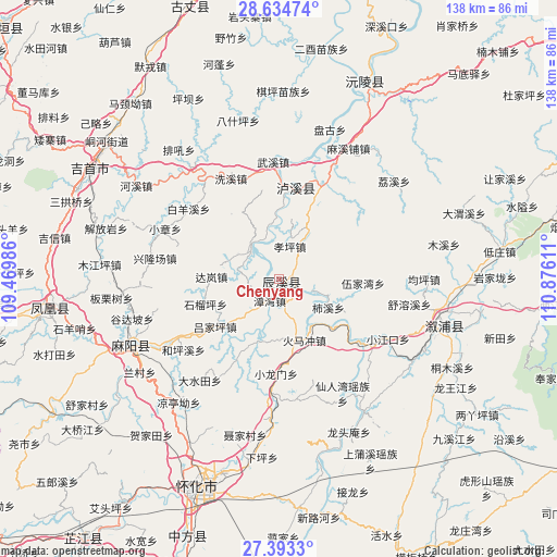
Chenyang GPS coordinates[2]
28° 0' 56.916" North, 110° 10' 22.728" East
| Map corner | latitude | longitude |
|---|---|---|
| Upper-left | 28.63474°, | 109.46986° |
| Center: | 28.01581°, | 110.17298° |
| Lower-right: | 27.3933°, | 110.87611° |
| Map W x H: | 138×138 km | = 85.7×85.7mi |
| max Lat: | 53.31946° ⇑74% North |
| Chenyang: | 28.01581° |
| min Lat: | ⇓26% South 18.22056° |
| min Long | Chenyang | max Long |
| 75.07348° | 110.17298° | 134.28917° |
| W 29.5%⇐ | ⇒70.5% E |
Elevation
Elevation of Chenyang is 206 m = 676 ft, and this is 278.8 m = 915 ft below average elevation for this country.
| Max E: |
5622 m = 18445 ft | 45% |
| Avg. | 484.8 m = 1591 ft | |
| Chenyang | 206 m = 676 ft | |
Min E: |
-3 m = -10 ft | 55% |
See also: China elevation on elevation.city.
Geographical zone
Chenyang is located in North temperate zone (between Tropic of Cancer and the Arctic Circle). Distance of this Northern Tropic circle is 509.1 km =316.3 mi to South.| Distance of | km | miles | from Chenyang |
|---|---|---|---|
| North Pole | 6892 | 4282.5 | to North |
| Arctic Circle | 4286.1 | 2663.3 | to North |
| Tropic Cancer | 509.1 | 316.3 | to South |
| Equator | 3115.1 | 1935.6 | to South |


Nearby cities:
15 places around Chenyang: (largest is in red/bold)
• Anping
17.5 km =10.9 mi,  198°
198°
• Baisha
23.1 km =14.4 mi,  10°
10°
• Chuanxi
19.4 km =12.1 mi,  26°
26°
• Heshui
24.3 km =15.1 mi,  260°
260°
• Huomachong
15.8 km =9.8 mi,  159°
159°
• Lanli
28.8 km =17.9 mi,  240°
240°
• Pushi
10.6 km =6.6 mi,  314°
314°
• Tanwan
5.9 km =3.7 mi, 202°
• Tianwan
10.5 km =6.5 mi, 34°
• Xiaojiangkou
30.8 km =19.1 mi,  119°
119°
• Xiaolongmen
23.8 km =14.8 mi,  182°
182°
• Xiaozhang
30.8 km =19.1 mi,  293°
293°
• Xinglongchang
31.9 km =19.8 mi,  277°
277°
• Xiuxi
12.7 km =7.9 mi,  109°
109°
• Yongping
25.4 km =15.8 mi,  53°
53°
Sources, notices
• [Note1] Compared only with cities in China existing in our database
• [Src1] Map data: © OpenStreetMap contributors (CC-BY-SA)
• [Src2] Other city data from geonames.org with taken over terms of usage.
• [Src3] Geographical zone / Annual Mean Temperature by Robert A. Rohde @ Wikipedia
