Lanli geodata
Lanli (Hunan) is a populated place; located in China in Asia/Shanghai (GMT+8) time zone. With population of 1,660 people, there are 1066 cities with bigger population in this country. Compared to other cities in China, 74.7% of cities are located further ↑North; 71.7% of cities are located further →East and 52.1% of cities have higher elevation than Lanli. Note1


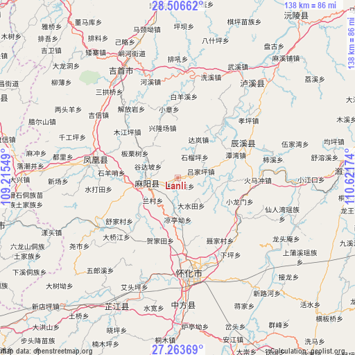
Lanli GPS coordinates[2]
27° 53' 12.984" North, 109° 55' 6.996" East
| Map corner | latitude | longitude |
|---|---|---|
| Upper-left | 28.50662°, | 109.21549° |
| Center: | 27.88694°, | 109.91861° |
| Lower-right: | 27.26369°, | 110.62174° |
| Map W x H: | 138.2×138.2 km | = 85.9×85.9mi |
| max Lat: | 53.31946° ⇑74.7% North |
| Lanli: | 27.88694° |
| min Lat: | ⇓25.3% South 18.22056° |
| min Long | Lanli | max Long |
| 75.07348° | 109.91861° | 134.28917° |
| W 28.3%⇐ | ⇒71.7% E |
Elevation
Elevation of Lanli is 149 m = 489 ft, and this is 335.8 m = 1102 ft below average elevation for this country.
| Max E: |
5622 m = 18445 ft | 52.1% |
| Avg. | 484.8 m = 1591 ft | |
| Lanli | 149 m = 489 ft | |
Min E: |
-3 m = -10 ft | 47.9% |
See also: China elevation on elevation.city.
Geographical zone
Lanli is located in North temperate zone (between Tropic of Cancer and the Arctic Circle). Distance of this Northern Tropic circle is 494.8 km =307.5 mi to South.| Distance of | km | miles | from Lanli |
|---|---|---|---|
| North Pole | 6906.3 | 4291.4 | to North |
| Arctic Circle | 4300.4 | 2672.1 | to North |
| Tropic Cancer | 494.8 | 307.5 | to South |
| Equator | 3100.7 | 1926.7 | to South |


Nearby cities:
15 places around Lanli: (largest is in red/bold)
• Anping
19.5 km =12.1 mi,  96°
96°
• Chenyang
28.8 km =17.9 mi,  60°
60°
• Gaocun
13.2 km =8.2 mi,  265°
265°
• Heshui
10.5 km =6.5 mi,  5°
5°
• Huangjin’ao
26.1 km =16.2 mi,  173°
173°
• Huaqiao
29.6 km =18.4 mi,  132°
132°
• Jiangkouxu
28 km =17.4 mi,  219°
219°
• Mujiangping
26.6 km =16.5 mi,  312°
312°
• Pushi
27.8 km =17.3 mi,  38°
38°
• Qiaoxikou
28.9 km =18 mi, 306°
• Tanwan
24.4 km =15.2 mi,  68°
68°
• Xiaolongmen
25.6 km =15.9 mi,  111°
111°
• Xiaozhang
26.9 km =16.7 mi,  352°
352°
• Xinglongchang
19.4 km =12.1 mi,  339°
339°
• Yanmen
17.9 km =11.1 mi,  258°
258°
Sources, notices
• [Note1] Compared only with cities in China existing in our database
• [Src1] Map data: © OpenStreetMap contributors (CC-BY-SA)
• [Src2] Other city data from geonames.org with taken over terms of usage.
• [Src3] Geographical zone / Annual Mean Temperature by Robert A. Rohde @ Wikipedia
