Hengzhou geodata
Hengzhou (Guangxi) is a seat of a third-order administrative division; located in China in Asia/Shanghai (GMT+8) time zone. In our database, there are 1268 cities with bigger population. Compared to other cities in China, 95.7% of cities are located further ↑North; 75.1% of cities are located further →East and 67.4% of cities have higher elevation than Hengzhou. Note1


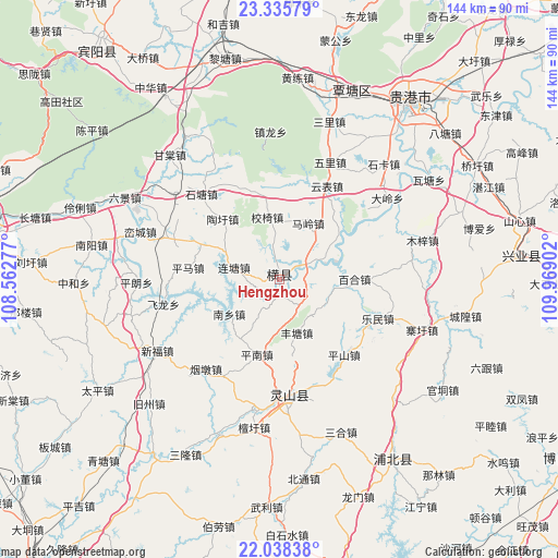
Hengzhou GPS coordinates[2]
22° 41' 19.032" North, 109° 15' 57.204" East
| Map corner | latitude | longitude |
|---|---|---|
| Upper-left | 23.33579°, | 108.56277° |
| Center: | 22.68862°, | 109.26589° |
| Lower-right: | 22.03838°, | 109.96902° |
| Map W x H: | 144.3×144.3 km | = 89.7×89.7mi |
| max Lat: | 53.31946° ⇑95.7% North |
| Hengzhou: | 22.68862° |
| min Lat: | ⇓4.3% South 18.22056° |
| min Long | Hengzhou | max Long |
| 75.07348° | 109.26589° | 134.28917° |
| W 24.9%⇐ | ⇒75.1% E |
Elevation
Elevation of Hengzhou is 63 m = 207 ft, and this is 421.8 m = 1384 ft below average elevation for this country.
| Max E: |
5622 m = 18445 ft | 67.4% |
| Avg. | 484.8 m = 1591 ft | |
| Hengzhou | 63 m = 207 ft | |
Min E: |
-3 m = -10 ft | 32.6% |
See also: China elevation on elevation.city.
Geographical zone
Hengzhou is located in North Torrid zone (between Equator and Tropic of Cancer). Distance of this Northern Tropic circle is 83.2 km =51.7 mi to North.| Distance of | km | miles | from Hengzhou |
|---|---|---|---|
| North Pole | 7484.3 | 4650.5 | to North |
| Arctic Circle | 4878.4 | 3031.3 | to North |
| Tropic Cancer | 83.2 | 51.7 | to North |
| Equator | 2522.7 | 1567.5 | to South |


Nearby cities:
15 places around Hengzhou: (largest is in red/bold)
• Bobai
86.3 km =53.6 mi,  122°
122°
• Dafeng
107.4 km =66.7 mi,  320°
320°
• Guigang
57.4 km =35.7 mi,  37°
37°
• Lingcheng
29.6 km =18.4 mi,  174°
174°
• Luxu
75.8 km =47.1 mi, 321°
• Nanning
98.4 km =61.1 mi,  278°
278°
• Pumiao
80.9 km =50.3 mi, 275°
• Qiaoxu
58.8 km =36.5 mi,  59°
59°
• Qinzhou
103.3 km =64.2 mi,  219°
219°
• Shinan
62.7 km =39 mi,  84°
84°
• Tantang
52.1 km =32.4 mi,  16°
16°
• Wenquan
109.4 km =68 mi,  111°
111°
• Xiaojiang
54.8 km =34.1 mi,  147°
147°
• Yashan
88.4 km =54.9 mi,  128°
128°
• Yulin
90.9 km =56.5 mi,  93°
93°
Sources, notices
• [Note1] Compared only with cities in China existing in our database
• [Src1] Map data: © OpenStreetMap contributors (CC-BY-SA)
• [Src2] Other city data from geonames.org with taken over terms of usage.
• [Src3] Geographical zone / Annual Mean Temperature by Robert A. Rohde @ Wikipedia
