Pumiao geodata
Pumiao (Guangxi) is a seat of a third-order administrative division; located in China in Asia/Shanghai (GMT+8) time zone. With population of 61,690 people, there are 705 cities with bigger population in this country. Compared to other cities in China, 95.5% of cities are located further ↑North; 78.6% of cities are located further →East and 61.9% of cities have higher elevation than Pumiao. Note1


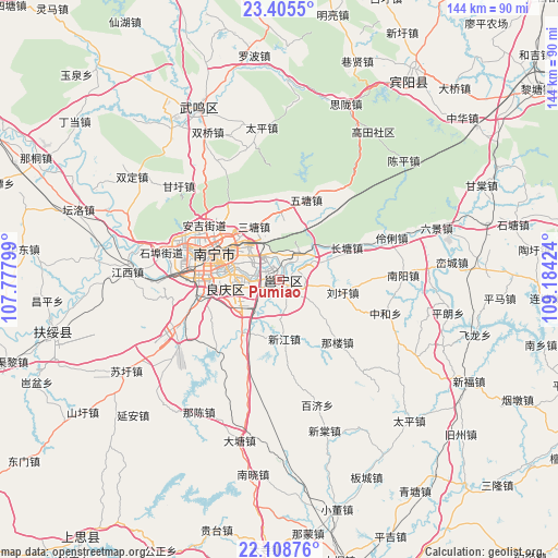
Pumiao GPS coordinates[2]
22° 45' 31.212" North, 108° 28' 51.996" East
| Map corner | latitude | longitude |
|---|---|---|
| Upper-left | 23.4055°, | 107.77799° |
| Center: | 22.75867°, | 108.48111° |
| Lower-right: | 22.10876°, | 109.18424° |
| Map W x H: | 144.2×144.2 km | = 89.6×89.6mi |
| max Lat: | 53.31946° ⇑95.5% North |
| Pumiao: | 22.75867° |
| min Lat: | ⇓4.5% South 18.22056° |
| min Long | Pumiao | max Long |
| 75.07348° | 108.48111° | 134.28917° |
| W 21.4%⇐ | ⇒78.6% E |
Elevation
Elevation of Pumiao is 88 m = 289 ft, and this is 396.8 m = 1302 ft below average elevation for this country.
| Max E: |
5622 m = 18445 ft | 61.9% |
| Avg. | 484.8 m = 1591 ft | |
| Pumiao | 88 m = 289 ft | |
Min E: |
-3 m = -10 ft | 38.1% |
See also: Pumiao elevation on elevation.city.
Geographical zone
Pumiao is located in North Torrid zone (between Equator and Tropic of Cancer). Distance of this Northern Tropic circle is 75.4 km =46.9 mi to North.| Distance of | km | miles | from Pumiao |
|---|---|---|---|
| North Pole | 7476.5 | 4645.7 | to North |
| Arctic Circle | 4870.6 | 3026.4 | to North |
| Tropic Cancer | 75.4 | 46.9 | to North |
| Equator | 2530.5 | 1572.4 | to South |


Nearby cities:
15 places around Pumiao: (largest is in red/bold)
• Baishan
110.8 km =68.8 mi,  343°
343°
• Chengxiang
49.3 km =30.6 mi, 335°
• Dafeng
76.1 km =47.3 mi,  9°
9°
• Guigang
121.5 km =75.5 mi,  71°
71°
• Hengzhou
80.9 km =50.3 mi,  95°
95°
• Lingcheng
91.3 km =56.7 mi,  114°
114°
• Long’an Chengxiangzhen
98.5 km =61.2 mi,  300°
300°
• Luxu
61.1 km =38 mi,  32°
32°
• Matou
115.5 km =71.8 mi,  305°
305°
• Nanning
18 km =11.2 mi,  290°
290°
• Qinzhou
88.6 km =55.1 mi,  170°
170°
• Siyang
85.8 km =53.3 mi,  220°
220°
• Tantang
104.3 km =64.8 mi, 66°
• Xiaojiang
122.5 km =76.1 mi,  116°
116°
• Xinning
61.5 km =38.2 mi,  260°
260°
Sources, notices
• [Note1] Compared only with cities in China existing in our database
• [Src1] Map data: © OpenStreetMap contributors (CC-BY-SA)
• [Src2] Other city data from geonames.org with taken over terms of usage.
• [Src3] Geographical zone / Annual Mean Temperature by Robert A. Rohde @ Wikipedia
