Tantang geodata
Tantang (Guangxi) is a seat of a third-order administrative division; located in China in Asia/Shanghai (GMT+8) time zone. In our database, there are 1268 cities with bigger population. Compared to other cities in China, 93.8% of cities are located further ↑North; 74.4% of cities are located further →East and 66.1% of cities have higher elevation than Tantang. Note1


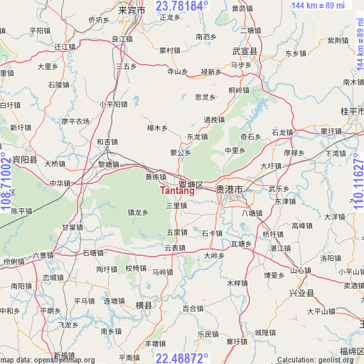
Tantang GPS coordinates[2]
23° 8' 12.624" North, 109° 24' 47.304" East
| Map corner | latitude | longitude |
|---|---|---|
| Upper-left | 23.78184°, | 108.71002° |
| Center: | 23.13684°, | 109.41314° |
| Lower-right: | 22.48872°, | 110.11627° |
| Map W x H: | 143.8×143.8 km | = 89.4×89.4mi |
| max Lat: | 53.31946° ⇑93.8% North |
| Tantang: | 23.13684° |
| min Lat: | ⇓6.2% South 18.22056° |
| min Long | Tantang | max Long |
| 75.07348° | 109.41314° | 134.28917° |
| W 25.6%⇐ | ⇒74.4% E |
Elevation
Elevation of Tantang is 68 m = 223 ft, and this is 416.8 m = 1367 ft below average elevation for this country.
| Max E: |
5622 m = 18445 ft | 66.1% |
| Avg. | 484.8 m = 1591 ft | |
| Tantang | 68 m = 223 ft | |
Min E: |
-3 m = -10 ft | 33.9% |
See also: China elevation on elevation.city.
Geographical zone
Tantang is located in North Torrid zone (between Equator and Tropic of Cancer). Distance of this Northern Tropic circle is 33.3 km =20.7 mi to North.| Distance of | km | miles | from Tantang |
|---|---|---|---|
| North Pole | 7434.5 | 4619.6 | to North |
| Arctic Circle | 4828.6 | 3000.4 | to North |
| Tropic Cancer | 33.3 | 20.7 | to North |
| Equator | 2572.6 | 1598.5 | to South |


Nearby cities:
15 places around Tantang: (largest is in red/bold)
• Dafeng
89.6 km =55.7 mi,  291°
291°
• Guigang
20.5 km =12.7 mi,  102°
102°
• Guiping
73.3 km =45.5 mi,  67°
67°
• Hengzhou
52.1 km =32.4 mi,  196°
196°
• Laibin
64.4 km =40 mi,  346°
346°
• Lingcheng
80.3 km =49.9 mi,  188°
188°
• Lingcheng
107.1 km =66.5 mi,  116°
116°
• Luxu
63.1 km =39.2 mi,  278°
278°
• Pumiao
104.3 km =64.8 mi,  246°
246°
• Qiaoxu
40.8 km =25.4 mi, 119°
• Shinan
64.3 km =40 mi,  132°
132°
• Wuxuan
59.5 km =37 mi,  24°
24°
• Xiangzhou
96.5 km =60 mi, 15°
• Xiaojiang
97.1 km =60.3 mi,  171°
171°
• Yulin
94 km =58.4 mi, 126°
Sources, notices
• [Note1] Compared only with cities in China existing in our database
• [Src1] Map data: © OpenStreetMap contributors (CC-BY-SA)
• [Src2] Other city data from geonames.org with taken over terms of usage.
• [Src3] Geographical zone / Annual Mean Temperature by Robert A. Rohde @ Wikipedia
