Dafeng geodata
Dafeng (Guangxi) is a seat of a third-order administrative division; located in China in Asia/Shanghai (GMT+8) time zone. In our database, there are 1268 cities with bigger population. Compared to other cities in China, 92.5% of cities are located further ↑North; 78.2% of cities are located further →East and 54.4% of cities have higher elevation than Dafeng. Note1


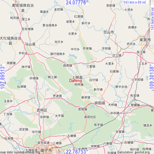
Dafeng GPS coordinates[2]
23° 26' 3.192" North, 108° 35' 53.7" East
| Map corner | latitude | longitude |
|---|---|---|
| Upper-left | 24.07776°, | 107.89513° |
| Center: | 23.43422°, | 108.59825° |
| Lower-right: | 22.78753°, | 109.30138° |
| Map W x H: | 143.5×143.5 km | = 89.2×89.2mi |
| max Lat: | 53.31946° ⇑92.5% North |
| Dafeng: | 23.43422° |
| min Lat: | ⇓7.5% South 18.22056° |
| min Long | Dafeng | max Long |
| 75.07348° | 108.59825° | 134.28917° |
| W 21.8%⇐ | ⇒78.2% E |
Elevation
Elevation of Dafeng is 135 m = 443 ft, and this is 349.8 m = 1148 ft below average elevation for this country.
| Max E: |
5622 m = 18445 ft | 54.4% |
| Avg. | 484.8 m = 1591 ft | |
| Dafeng | 135 m = 443 ft | |
Min E: |
-3 m = -10 ft | 45.6% |
See also: China elevation on elevation.city.
Geographical zone
Dafeng is located in North Torrid zone (between Equator and Tropic of Cancer). Distance of this Northern Tropic circle is 0.3 km =0.2 mi to North.| Distance of | km | miles | from Dafeng |
|---|---|---|---|
| North Pole | 7401.4 | 4599 | to North |
| Arctic Circle | 4795.5 | 2979.8 | to North |
| Tropic Cancer | 0.3 | 0.2 | to North |
| Equator | 2605.6 | 1619 | to South |


Nearby cities:
15 places around Dafeng: (largest is in red/bold)
• Anyang
75.7 km =47 mi,  317°
317°
• Baishan
53.5 km =33.2 mi,  305°
305°
• Chengxiang
44.7 km =27.8 mi,  227°
227°
• Dahua
72.8 km =45.2 mi,  300°
300°
• Guigang
109.9 km =68.3 mi,  109°
109°
• Hengzhou
107.4 km =66.7 mi,  140°
140°
• Laibin
74.3 km =46.2 mi,  66°
66°
• Long’an Chengxiangzhen
100 km =62.1 mi,  255°
255°
• Luxu
31.6 km =19.6 mi, 138°
• Matou
106.7 km =66.3 mi,  265°
265°
• Nanning
74.5 km =46.3 mi,  202°
202°
• Pumiao
76.1 km =47.3 mi,  189°
189°
• Tantang
89.6 km =55.7 mi, 111°
• Wuxuan
109.5 km =68 mi,  78°
78°
• Xincheng Chengguanzhen
72.7 km =45.2 mi,  4°
4°
Sources, notices
• [Note1] Compared only with cities in China existing in our database
• [Src1] Map data: © OpenStreetMap contributors (CC-BY-SA)
• [Src2] Other city data from geonames.org with taken over terms of usage.
• [Src3] Geographical zone / Annual Mean Temperature by Robert A. Rohde @ Wikipedia
