Changlai geodata
Changlai (Guangdong) is a seat of a fourth-order administrative division; located in China in Asia/Shanghai (GMT+8) time zone. In our database, there are 1268 cities with bigger population. Compared to other cities in China, 86% of cities are located further ↑North; 55% of cities are located further →East and 61.9% of cities have higher elevation than Changlai. Note1


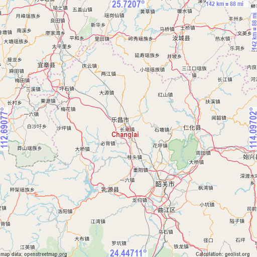
Changlai GPS coordinates[2]
25° 5' 8.016" North, 113° 23' 38.004" East
| Map corner | latitude | longitude |
|---|---|---|
| Upper-left | 25.7207°, | 112.69077° |
| Center: | 25.08556°, | 113.39389° |
| Lower-right: | 24.44711°, | 114.09702° |
| Map W x H: | 141.6×141.6 km | = 88×88mi |
| max Lat: | 53.31946° ⇑86% North |
| Changlai: | 25.08556° |
| min Lat: | ⇓14% South 18.22056° |
| min Long | Changlai | max Long |
| 75.07348° | 113.39389° | 134.28917° |
| W 45%⇐ | ⇒55% E |
Elevation
Elevation of Changlai is 88 m = 289 ft, and this is 396.8 m = 1302 ft below average elevation for this country.
| Max E: |
5622 m = 18445 ft | 61.9% |
| Avg. | 484.8 m = 1591 ft | |
| Changlai | 88 m = 289 ft | |
Min E: |
-3 m = -10 ft | 38.1% |
See also: China elevation on elevation.city.
Geographical zone
Changlai is located in North temperate zone (between Tropic of Cancer and the Arctic Circle). Distance of this Northern Tropic circle is 183.3 km =113.9 mi to South.| Distance of | km | miles | from Changlai |
|---|---|---|---|
| North Pole | 7217.8 | 4484.9 | to North |
| Arctic Circle | 4611.9 | 2865.7 | to North |
| Tropic Cancer | 183.3 | 113.9 | to South |
| Equator | 2789.3 | 1733.2 | to South |


Nearby cities:
15 places around Changlai: (largest is in red/bold)
• Beixiang
12.6 km =7.8 mi,  344°
344°
• Bibei
14.2 km =8.8 mi,  233°
233°
• Dayuan
23.6 km =14.7 mi,  332°
332°
• Dongtang
23.8 km =14.8 mi,  91°
91°
• Guitou
17.1 km =10.6 mi,  172°
172°
• Hongshan
27.5 km =17.1 mi,  46°
46°
• Huaping
19.7 km =12.2 mi,  114°
114°
• Langtian
9.8 km =6.1 mi,  37°
37°
• Lecheng
6.4 km =4 mi,  317°
317°
• Lishi
24.4 km =15.2 mi,  147°
147°
• Shitang
17.5 km =10.9 mi, 93°
• Wushan
20.3 km =12.6 mi,  25°
25°
• Yiliu
27.8 km =17.3 mi,  177°
177°
• Youxi
14.7 km =9.1 mi,  193°
193°
• Zhongyang
23.3 km =14.5 mi,  163°
163°
Sources, notices
• [Note1] Compared only with cities in China existing in our database
• [Src1] Map data: © OpenStreetMap contributors (CC-BY-SA)
• [Src2] Other city data from geonames.org with taken over terms of usage.
• [Src3] Geographical zone / Annual Mean Temperature by Robert A. Rohde @ Wikipedia
