Guanzhuang geodata
Guanzhuang (Hunan) is a seat of a fourth-order administrative division; located in China in Asia/Shanghai (GMT+8) time zone. In our database, there are 1268 cities with bigger population. Compared to other cities in China, 69.4% of cities are located further ↑North; 67.4% of cities are located further →East and 57% of cities have lower elevation than Guanzhuang. Note1


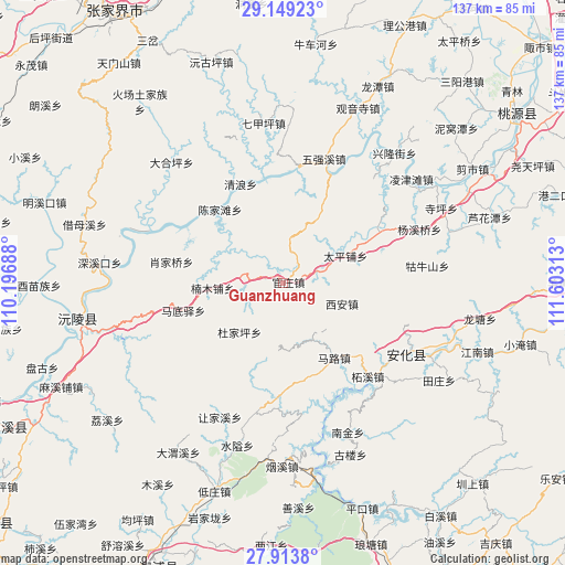
Guanzhuang GPS coordinates[2]
28° 31' 59.988" North, 110° 54' 0" East
| Map corner | latitude | longitude |
|---|---|---|
| Upper-left | 29.14923°, | 110.19688° |
| Center: | 28.53333°, | 110.9° |
| Lower-right: | 27.9138°, | 111.60313° |
| Map W x H: | 137.4×137.4 km | = 85.4×85.4mi |
| max Lat: | 53.31946° ⇑69.4% North |
| Guanzhuang: | 28.53333° |
| min Lat: | ⇓30.6% South 18.22056° |
| min Long | Guanzhuang | max Long |
| 75.07348° | 110.9° | 134.28917° |
| W 32.6%⇐ | ⇒67.4% E |
Elevation
Elevation of Guanzhuang is 226 m = 741 ft, and this is 258.8 m = 849 ft below average elevation for this country.
| Max E: |
5622 m = 18445 ft | 43% |
| Avg. | 484.8 m = 1591 ft | |
| Guanzhuang | 226 m = 741 ft | |
Min E: |
-3 m = -10 ft | 57% |
See also: China elevation on elevation.city.
Geographical zone
Guanzhuang is located in North temperate zone (between Tropic of Cancer and the Arctic Circle). Distance of this Northern Tropic circle is 566.7 km =352.1 mi to South.| Distance of | km | miles | from Guanzhuang |
|---|---|---|---|
| North Pole | 6834.5 | 4246.8 | to North |
| Arctic Circle | 4228.6 | 2627.5 | to North |
| Tropic Cancer | 566.7 | 352.1 | to South |
| Equator | 3172.6 | 1971.4 | to South |


Nearby cities:
15 places around Guanzhuang: (largest is in red/bold)
• Cangchang
18.1 km =11.2 mi,  171°
171°
• Canmang
42.9 km =26.7 mi,  358°
358°
• Cha’anpu
27.5 km =17.1 mi,  65°
65°
• Chenjiatan
22.2 km =13.8 mi,  318°
318°
• Dongping
34.4 km =21.4 mi,  119°
119°
• Gulou
45.2 km =28.1 mi,  154°
154°
• Guniushan
35.3 km =21.9 mi,  87°
87°
• Huangrangping
19.3 km =12 mi,  30°
30°
• Kuixi
34.3 km =21.3 mi,  193°
193°
• Luoping
39.2 km =24.4 mi,  295°
295°
• Nanmu
38.7 km =24 mi,  1°
1°
• Qijiaping
39.3 km =24.4 mi,  353°
353°
• Qijiaxi
44.7 km =27.8 mi,  326°
326°
• Siping
42.6 km =26.5 mi, 65°
• Xi’an
16.4 km =10.2 mi, 116°
Sources, notices
• [Note1] Compared only with cities in China existing in our database
• [Src1] Map data: © OpenStreetMap contributors (CC-BY-SA)
• [Src2] Other city data from geonames.org with taken over terms of usage.
• [Src3] Geographical zone / Annual Mean Temperature by Robert A. Rohde @ Wikipedia
