Cha’anpu geodata
Cha’anpu (Hunan) is a seat of a fourth-order administrative division; located in China in Asia/Shanghai (GMT+8) time zone. In our database, there are 1268 cities with bigger population. Compared to other cities in China, 68.6% of cities are located further ↑North; 66.4% of cities are located further →East and 56% of cities have higher elevation than Cha’anpu. Note1


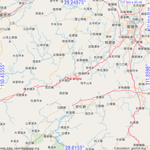
Cha’anpu GPS coordinates[2]
28° 38' 3.984" North, 111° 9' 24.012" East
| Map corner | latitude | longitude |
|---|---|---|
| Upper-left | 29.24975°, | 110.45355° |
| Center: | 28.63444°, | 111.15667° |
| Lower-right: | 28.0155°, | 111.8598° |
| Map W x H: | 137.2×137.2 km | = 85.3×85.3mi |
| max Lat: | 53.31946° ⇑68.6% North |
| Cha’anpu: | 28.63444° |
| min Lat: | ⇓31.4% South 18.22056° |
| min Long | Cha’anpu | max Long |
| 75.07348° | 111.15667° | 134.28917° |
| W 33.6%⇐ | ⇒66.4% E |
Elevation
Elevation of Cha’anpu is 124 m = 407 ft, and this is 360.8 m = 1184 ft below average elevation for this country.
| Max E: |
5622 m = 18445 ft | 56% |
| Avg. | 484.8 m = 1591 ft | |
| Cha’anpu | 124 m = 407 ft | |
Min E: |
-3 m = -10 ft | 44% |
See also: China elevation on elevation.city.
Geographical zone
Cha’anpu is located in North temperate zone (between Tropic of Cancer and the Arctic Circle). Distance of this Northern Tropic circle is 577.9 km =359.1 mi to South.| Distance of | km | miles | from Cha’anpu |
|---|---|---|---|
| North Pole | 6823.2 | 4239.7 | to North |
| Arctic Circle | 4217.3 | 2620.5 | to North |
| Tropic Cancer | 577.9 | 359.1 | to South |
| Equator | 3183.9 | 1978.4 | to South |


Nearby cities:
15 places around Cha’anpu: (largest is in red/bold)
• Cangchang
36.8 km =22.9 mi,  217°
217°
• Dongping
28.7 km =17.8 mi,  170°
170°
• Guanyinsi
32.1 km =19.9 mi,  347°
347°
• Guanzhuang
27.5 km =17.1 mi,  245°
245°
• Guniushan
14.2 km =8.8 mi,  133°
133°
• Huangrangping
16.2 km =10.1 mi,  289°
289°
• Longtan
36.5 km =22.7 mi,  356°
356°
• Longtang
32.1 km =19.9 mi, 131°
• Luhuatan
26.4 km =16.4 mi,  81°
81°
• Nanmu
36.5 km =22.7 mi,  318°
318°
• Nijiangping
35.9 km =22.3 mi, 78°
• Shenshuigang
39.1 km =24.3 mi,  36°
36°
• Siping
15.2 km =9.4 mi,  65°
65°
• Taohuayuan
32.1 km =19.9 mi,  60°
60°
• Xi’an
21.4 km =13.3 mi,  209°
209°
Sources, notices
• [Note1] Compared only with cities in China existing in our database
• [Src1] Map data: © OpenStreetMap contributors (CC-BY-SA)
• [Src2] Other city data from geonames.org with taken over terms of usage.
• [Src3] Geographical zone / Annual Mean Temperature by Robert A. Rohde @ Wikipedia
