Dongping geodata
Dongping (Hunan) is a seat of a third-order administrative division; located in China in Asia/Shanghai (GMT+8) time zone. In our database, there are 1268 cities with bigger population. Compared to other cities in China, 70.8% of cities are located further ↑North; 66.2% of cities are located further →East and 54.4% of cities have higher elevation than Dongping. Note1


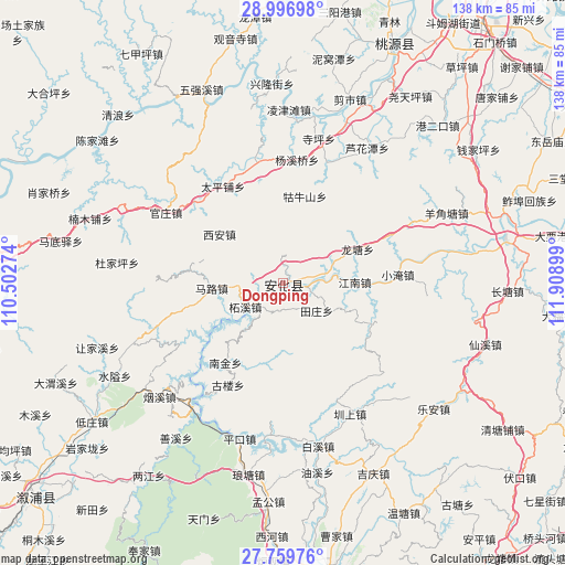
Dongping GPS coordinates[2]
28° 22' 48.612" North, 111° 12' 21.096" East
| Map corner | latitude | longitude |
|---|---|---|
| Upper-left | 28.99698°, | 110.50274° |
| Center: | 28.38017°, | 111.20586° |
| Lower-right: | 27.75976°, | 111.90899° |
| Map W x H: | 137.6×137.6 km | = 85.5×85.5mi |
| max Lat: | 53.31946° ⇑70.8% North |
| Dongping: | 28.38017° |
| min Lat: | ⇓29.2% South 18.22056° |
| min Long | Dongping | max Long |
| 75.07348° | 111.20586° | 134.28917° |
| W 33.8%⇐ | ⇒66.2% E |
Elevation
Elevation of Dongping is 135 m = 443 ft, and this is 349.8 m = 1148 ft below average elevation for this country.
| Max E: |
5622 m = 18445 ft | 54.4% |
| Avg. | 484.8 m = 1591 ft | |
| Dongping | 135 m = 443 ft | |
Min E: |
-3 m = -10 ft | 45.6% |
See also: China elevation on elevation.city.
Geographical zone
Dongping is located in North temperate zone (between Tropic of Cancer and the Arctic Circle). Distance of this Northern Tropic circle is 549.7 km =341.6 mi to South.| Distance of | km | miles | from Dongping |
|---|---|---|---|
| North Pole | 6851.5 | 4257.3 | to North |
| Arctic Circle | 4245.6 | 2638.1 | to North |
| Tropic Cancer | 549.7 | 341.6 | to South |
| Equator | 3155.6 | 1960.8 | to South |


Nearby cities:
15 places around Dongping: (largest is in red/bold)
• Baixi
42.1 km =26.2 mi,  166°
166°
• Cangchang
27.3 km =17 mi,  268°
268°
• Cha’anpu
28.7 km =17.8 mi,  350°
350°
• Guanzhuang
34.4 km =21.4 mi,  299°
299°
• Gulou
25.9 km =16.1 mi,  203°
203°
• Guniushan
19.2 km =11.9 mi,  16°
16°
• Huangrangping
39.3 km =24.4 mi,  329°
329°
• Kuixi
41.5 km =25.8 mi,  246°
246°
• Langtang
42.1 km =26.2 mi,  187°
187°
• Longtang
20.4 km =12.7 mi,  70°
70°
• Luhuatan
38.5 km =23.9 mi,  33°
33°
• Siping
35.6 km =22.1 mi,  14°
14°
• Xi’an
18 km =11.2 mi, 302°
• Yangjiaotang
44.1 km =27.4 mi, 67°
• Zhenshang
35.7 km =22.2 mi,  150°
150°
Sources, notices
• [Note1] Compared only with cities in China existing in our database
• [Src1] Map data: © OpenStreetMap contributors (CC-BY-SA)
• [Src2] Other city data from geonames.org with taken over terms of usage.
• [Src3] Geographical zone / Annual Mean Temperature by Robert A. Rohde @ Wikipedia
