Ganshui geodata
Ganshui (Chongqing) is a seat of a fourth-order administrative division; located in China in Asia/Shanghai (GMT+8) time zone. With population of 5,300 people, there are 863 cities with bigger population in this country. Compared to other cities in China, 67.5% of cities are located further ↑North; 84.5% of cities are located further →East and 70.1% of cities have lower elevation than Ganshui. Note1


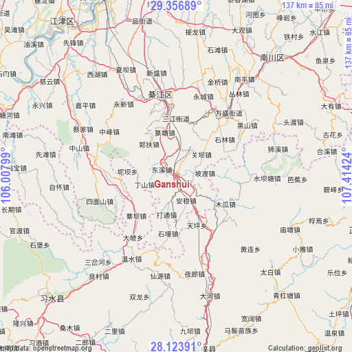
Ganshui GPS coordinates[2]
28° 44' 31.992" North, 106° 42' 39.996" East
| Map corner | latitude | longitude |
|---|---|---|
| Upper-left | 29.35689°, | 106.00799° |
| Center: | 28.74222°, | 106.71111° |
| Lower-right: | 28.12391°, | 107.41424° |
| Map W x H: | 137.1×137.1 km | = 85.2×85.2mi |
| max Lat: | 53.31946° ⇑67.5% North |
| Ganshui: | 28.74222° |
| min Lat: | ⇓32.5% South 18.22056° |
| min Long | Ganshui | max Long |
| 75.07348° | 106.71111° | 134.28917° |
| W 15.5%⇐ | ⇒84.5% E |
Elevation
Elevation of Ganshui is 414 m = 1358 ft, and this is 70.8 m = 232 ft below average elevation for this country.
| Max E: |
5622 m = 18445 ft | 29.9% |
| Avg. | 484.8 m = 1591 ft | |
| Ganshui | 414 m = 1358 ft | |
Min E: |
-3 m = -10 ft | 70.1% |
See also: China elevation on elevation.city.
Geographical zone
Ganshui is located in North temperate zone (between Tropic of Cancer and the Arctic Circle). Distance of this Northern Tropic circle is 589.9 km =366.5 mi to South.| Distance of | km | miles | from Ganshui |
|---|---|---|---|
| North Pole | 6811.2 | 4232.3 | to North |
| Arctic Circle | 4205.3 | 2613.1 | to North |
| Tropic Cancer | 589.9 | 366.5 | to South |
| Equator | 3195.8 | 1985.8 | to South |


Nearby cities:
15 places around Ganshui: (largest is in red/bold)
• Anwen
8.2 km =5.1 mi,  147°
147°
• Bailin
24.4 km =15.2 mi,  268°
268°
• Datong
16.8 km =10.4 mi,  194°
194°
• Dongxi
5.3 km =3.3 mi,  293°
293°
• Guanba
11.4 km =7.1 mi,  54°
54°
• Guofuchang
16.1 km =10 mi,  318°
318°
• Nantong
25.7 km =16 mi,  36°
36°
• Podu
11.3 km =7 mi,  83°
83°
• Puhechang
26.1 km =16.2 mi,  26°
26°
• Sanjiang
22.5 km =14 mi,  359°
359°
• Shijiaochang
20.7 km =12.9 mi,  12°
12°
• Shilin
23.9 km =14.9 mi, 51°
• Songkan
25.9 km =16.1 mi, 145°
• Yangdeng
24.4 km =15.2 mi,  96°
96°
• Zhaiba
21.7 km =13.5 mi,  224°
224°
Sources, notices
• [Note1] Compared only with cities in China existing in our database
• [Src1] Map data: © OpenStreetMap contributors (CC-BY-SA)
• [Src2] Other city data from geonames.org with taken over terms of usage.
• [Src3] Geographical zone / Annual Mean Temperature by Robert A. Rohde @ Wikipedia
