Datong geodata
Datong (Chongqing) is a seat of a fourth-order administrative division; located in China in Asia/Shanghai (GMT+8) time zone. In our database, there are 1268 cities with bigger population. Compared to other cities in China, 68.9% of cities are located further ↑North; 84.6% of cities are located further →East and 81.7% of cities have lower elevation than Datong. Note1


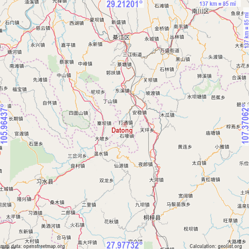
Datong GPS coordinates[2]
28° 35' 47.328" North, 106° 40' 2.964" East
| Map corner | latitude | longitude |
|---|---|---|
| Upper-left | 29.21201°, | 105.96437° |
| Center: | 28.59648°, | 106.66749° |
| Lower-right: | 27.97732°, | 107.37062° |
| Map W x H: | 137.3×137.3 km | = 85.3×85.3mi |
| max Lat: | 53.31946° ⇑68.9% North |
| Datong: | 28.59648° |
| min Lat: | ⇓31.1% South 18.22056° |
| min Long | Datong | max Long |
| 75.07348° | 106.66749° | 134.28917° |
| W 15.4%⇐ | ⇒84.6% E |
Elevation
Elevation of Datong is 772 m = 2533 ft, and this is 287.2 m = 942 ft above average elevation for this country.
| Max E: |
5622 m = 18445 ft | 18.3% |
| Datong | 772 m 2533 ft | |
| Avg. | 484.8 m = 1591 ft | |
Min E: |
-3 m = -10 ft | 81.7% |
See also: China elevation on elevation.city.
Geographical zone
Datong is located in North temperate zone (between Tropic of Cancer and the Arctic Circle). Distance of this Northern Tropic circle is 573.7 km =356.5 mi to South.| Distance of | km | miles | from Datong |
|---|---|---|---|
| North Pole | 6827.4 | 4242.3 | to North |
| Arctic Circle | 4221.5 | 2623.1 | to North |
| Tropic Cancer | 573.7 | 356.5 | to South |
| Equator | 3179.6 | 1975.7 | to South |


Nearby cities:
15 places around Datong: (largest is in red/bold)
• Anwen
12.7 km =7.9 mi,  43°
43°
• Bailin
25.5 km =15.8 mi,  307°
307°
• Dongxi
18.3 km =11.4 mi,  358°
358°
• Ganshui
16.8 km =10.4 mi,  14°
14°
• Guanba
26.5 km =16.5 mi,  30°
30°
• Guofuchang
28.9 km =18 mi,  347°
347°
• Podu
23.4 km =14.5 mi, 41°
• Sanchahe
25.9 km =16.1 mi,  244°
244°
• Songkan
19.5 km =12.1 mi,  105°
105°
• Wenshui
21.3 km =13.2 mi,  220°
220°
• Xianyuan
24.6 km =15.3 mi,  195°
195°
• Xinzhan
29.6 km =18.4 mi,  141°
141°
• Yangdeng
31.5 km =19.6 mi,  64°
64°
• Yelang
24.2 km =15 mi,  153°
153°
• Zhaiba
10.9 km =6.8 mi,  273°
273°
Sources, notices
• [Note1] Compared only with cities in China existing in our database
• [Src1] Map data: © OpenStreetMap contributors (CC-BY-SA)
• [Src2] Other city data from geonames.org with taken over terms of usage.
• [Src3] Geographical zone / Annual Mean Temperature by Robert A. Rohde @ Wikipedia
