Shilin geodata
Shilin (Chongqing) is a seat of a fourth-order administrative division; located in China in Asia/Shanghai (GMT+8) time zone. In our database, there are 1268 cities with bigger population. Compared to other cities in China, 66.6% of cities are located further ↑North; 84% of cities are located further →East and 71.4% of cities have lower elevation than Shilin. Note1


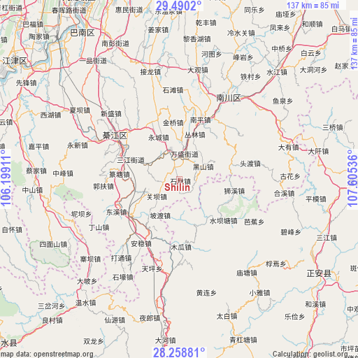
Shilin GPS coordinates[2]
28° 52' 34.788" North, 106° 54' 8.028" East
| Map corner | latitude | longitude |
|---|---|---|
| Upper-left | 29.4902°, | 106.19911° |
| Center: | 28.87633°, | 106.90223° |
| Lower-right: | 28.25881°, | 107.60536° |
| Map W x H: | 136.9×136.9 km | = 85.1×85.1mi |
| max Lat: | 53.31946° ⇑66.6% North |
| Shilin: | 28.87633° |
| min Lat: | ⇓33.4% South 18.22056° |
| min Long | Shilin | max Long |
| 75.07348° | 106.90223° | 134.28917° |
| W 16%⇐ | ⇒84% E |
Elevation
Elevation of Shilin is 438 m = 1437 ft, and this is 46.8 m = 154 ft below average elevation for this country.
| Max E: |
5622 m = 18445 ft | 28.6% |
| Avg. | 484.8 m = 1591 ft | |
| Shilin | 438 m = 1437 ft | |
Min E: |
-3 m = -10 ft | 71.4% |
See also: China elevation on elevation.city.
Geographical zone
Shilin is located in North temperate zone (between Tropic of Cancer and the Arctic Circle). Distance of this Northern Tropic circle is 604.8 km =375.8 mi to South.| Distance of | km | miles | from Shilin |
|---|---|---|---|
| North Pole | 6796.3 | 4223 | to North |
| Arctic Circle | 4190.4 | 2603.8 | to North |
| Tropic Cancer | 604.8 | 375.8 | to South |
| Equator | 3210.7 | 1995 | to South |


Nearby cities:
15 places around Shilin: (largest is in red/bold)
• Conglin
18.4 km =11.4 mi,  21°
21°
• Ganshui
23.9 km =14.9 mi,  231°
231°
• Guanba
12.5 km =7.8 mi, 228°
• Jinqiao
19.2 km =11.9 mi,  355°
355°
• Jinshan
20.6 km =12.8 mi,  72°
72°
• Longsheng
24.3 km =15.1 mi,  339°
339°
• Nantong
6.7 km =4.2 mi,  330°
330°
• Podu
15.5 km =9.6 mi,  208°
208°
• Puhechang
10.9 km =6.8 mi,  320°
320°
• Sanjiang
20.1 km =12.5 mi,  292°
292°
• Shijiaochang
15.2 km =9.4 mi, 290°
• Shixi
21.4 km =13.3 mi,  101°
101°
• Shuibatang
22.9 km =14.2 mi,  132°
132°
• Wansheng
10 km =6.2 mi,  14°
14°
• Yangdeng
18.6 km =11.6 mi,  162°
162°
Sources, notices
• [Note1] Compared only with cities in China existing in our database
• [Src1] Map data: © OpenStreetMap contributors (CC-BY-SA)
• [Src2] Other city data from geonames.org with taken over terms of usage.
• [Src3] Geographical zone / Annual Mean Temperature by Robert A. Rohde @ Wikipedia
