Nantong geodata
Nantong (Chongqing) is a seat of a fourth-order administrative division; located in China in Asia/Shanghai (GMT+8) time zone. In our database, there are 1268 cities with bigger population. Compared to other cities in China, 66.1% of cities are located further ↑North; 84.1% of cities are located further →East and 66.1% of cities have lower elevation than Nantong. Note1


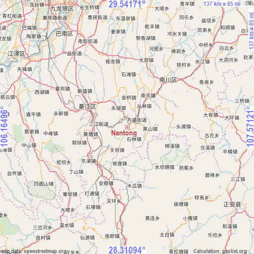
Nantong GPS coordinates[2]
28° 55' 41.34" North, 106° 52' 5.088" East
| Map corner | latitude | longitude |
|---|---|---|
| Upper-left | 29.54171°, | 106.16496° |
| Center: | 28.92815°, | 106.86808° |
| Lower-right: | 28.31094°, | 107.57121° |
| Map W x H: | 136.8×136.8 km | = 85×85mi |
| max Lat: | 53.31946° ⇑66.1% North |
| Nantong: | 28.92815° |
| min Lat: | ⇓33.9% South 18.22056° |
| min Long | Nantong | max Long |
| 75.07348° | 106.86808° | 134.28917° |
| W 15.9%⇐ | ⇒84.1% E |
Elevation
Elevation of Nantong is 344 m = 1129 ft, and this is 140.8 m = 462 ft below average elevation for this country.
| Max E: |
5622 m = 18445 ft | 33.9% |
| Avg. | 484.8 m = 1591 ft | |
| Nantong | 344 m = 1129 ft | |
Min E: |
-3 m = -10 ft | 66.1% |
See also: China elevation on elevation.city.
Geographical zone
Nantong is located in North temperate zone (between Tropic of Cancer and the Arctic Circle). Distance of this Northern Tropic circle is 610.6 km =379.4 mi to South.| Distance of | km | miles | from Nantong |
|---|---|---|---|
| North Pole | 6790.6 | 4219.5 | to North |
| Arctic Circle | 4184.7 | 2600.3 | to North |
| Tropic Cancer | 610.6 | 379.4 | to South |
| Equator | 3216.5 | 1998.6 | to South |


Nearby cities:
15 places around Nantong: (largest is in red/bold)
• Conglin
15.1 km =9.4 mi,  41°
41°
• Ganshui
25.7 km =16 mi,  216°
216°
• Guanba
15.3 km =9.5 mi,  203°
203°
• Gunan
23.9 km =14.9 mi,  296°
296°
• Jinqiao
13.5 km =8.4 mi,  7°
7°
• Jinshan
23 km =14.3 mi,  89°
89°
• Longsheng
17.8 km =11.1 mi,  343°
343°
• Podu
19.8 km =12.3 mi,  191°
191°
• Puhechang
4.5 km =2.8 mi,  306°
306°
• Sanjiang
15.4 km =9.6 mi,  276°
276°
• Sanjiao
18.7 km =11.6 mi,  316°
316°
• Shijiaochang
10.9 km =6.8 mi,  267°
267°
• Shilin
6.7 km =4.2 mi,  150°
150°
• Wansheng
7 km =4.3 mi,  56°
56°
• Yangdeng
25.1 km =15.6 mi,  159°
159°
Sources, notices
• [Note1] Compared only with cities in China existing in our database
• [Src1] Map data: © OpenStreetMap contributors (CC-BY-SA)
• [Src2] Other city data from geonames.org with taken over terms of usage.
• [Src3] Geographical zone / Annual Mean Temperature by Robert A. Rohde @ Wikipedia
