Fengshan geodata
Fengshan (Hubei) is a seat of a third-order administrative division; located in China in Asia/Shanghai (GMT+8) time zone. In our database, there are 1268 cities with bigger population. Compared to other cities in China, 53.7% of cities are located further ↓South; 56.5% of cities are located further ←West and 60.3% of cities have higher elevation than Fengshan. Note1


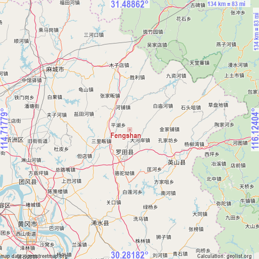
Fengshan GPS coordinates[2]
30° 53' 13.632" North, 115° 25' 15.276" East
| Map corner | latitude | longitude |
|---|---|---|
| Upper-left | 31.48862°, | 114.71779° |
| Center: | 30.88712°, | 115.42091° |
| Lower-right: | 30.28182°, | 116.12404° |
| Map W x H: | 134.2×134.2 km | = 83.4×83.4mi |
| max Lat: | 53.31946° ⇑46.3% North |
| Fengshan: | 30.88712° |
| min Lat: | ⇓53.7% South 18.22056° |
| min Long | Fengshan | max Long |
| 75.07348° | 115.42091° | 134.28917° |
| W 56.5%⇐ | ⇒43.5% E |
Elevation
Elevation of Fengshan is 97 m = 318 ft, and this is 387.8 m = 1272 ft below average elevation for this country.
| Max E: |
5622 m = 18445 ft | 60.3% |
| Avg. | 484.8 m = 1591 ft | |
| Fengshan | 97 m = 318 ft | |
Min E: |
-3 m = -10 ft | 39.7% |
See also: China elevation on elevation.city.
Geographical zone
Fengshan is located in North temperate zone (between Tropic of Cancer and the Arctic Circle). Distance of this Northern Tropic circle is 828.4 km =514.7 mi to South.| Distance of | km | miles | from Fengshan |
|---|---|---|---|
| North Pole | 6572.7 | 4084.1 | to North |
| Arctic Circle | 3966.8 | 2464.9 | to North |
| Tropic Cancer | 828.4 | 514.7 | to South |
| Equator | 3434.3 | 2134 | to South |


Nearby cities:
15 places around Fengshan: (largest is in red/bold)
• Baimiaohe
21.4 km =13.3 mi,  53°
53°
• Dahe’an
7.5 km =4.7 mi,  134°
134°
• Daqi
22.3 km =13.9 mi,  260°
260°
• Fengshan
11.3 km =7 mi,  194°
194°
• Hepu
12.4 km =7.7 mi,  342°
342°
• Hongshan
25.5 km =15.8 mi,  120°
120°
• Jinjiapu
20.5 km =12.7 mi,  88°
88°
• Kongjiafang
20.5 km =12.7 mi,  104°
104°
• Kuanghe
24 km =14.9 mi,  147°
147°
• Luotuo’ao
22.5 km =14 mi, 186°
• Pinghu
6.5 km =4 mi,  292°
292°
• Sanlifan
15.8 km =9.8 mi,  248°
248°
• Tuanbei
25.5 km =15.8 mi,  226°
226°
• Yantianhe
25.5 km =15.8 mi, 291°
• Zhangjiafan
20.9 km =13 mi,  330°
330°
Sources, notices
• [Note1] Compared only with cities in China existing in our database
• [Src1] Map data: © OpenStreetMap contributors (CC-BY-SA)
• [Src2] Other city data from geonames.org with taken over terms of usage.
• [Src3] Geographical zone / Annual Mean Temperature by Robert A. Rohde @ Wikipedia
