Kongjiafang geodata
Kongjiafang (Hubei) is a seat of a fourth-order administrative division; located in China in Asia/Shanghai (GMT+8) time zone. In our database, there are 1268 cities with bigger population. Compared to other cities in China, 53.3% of cities are located further ↓South; 57.7% of cities are located further ←West and 54.4% of cities have higher elevation than Kongjiafang. Note1


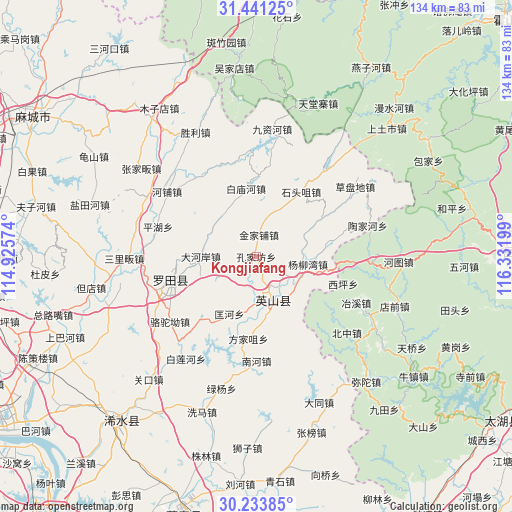
Kongjiafang GPS coordinates[2]
30° 50' 22.02" North, 115° 37' 43.896" East
| Map corner | latitude | longitude |
|---|---|---|
| Upper-left | 31.44125°, | 114.92574° |
| Center: | 30.83945°, | 115.62886° |
| Lower-right: | 30.23385°, | 116.33199° |
| Map W x H: | 134.3×134.3 km | = 83.5×83.5mi |
| max Lat: | 53.31946° ⇑46.7% North |
| Kongjiafang: | 30.83945° |
| min Lat: | ⇓53.3% South 18.22056° |
| min Long | Kongjiafang | max Long |
| 75.07348° | 115.62886° | 134.28917° |
| W 57.7%⇐ | ⇒42.3% E |
Elevation
Elevation of Kongjiafang is 135 m = 443 ft, and this is 349.8 m = 1148 ft below average elevation for this country.
| Max E: |
5622 m = 18445 ft | 54.4% |
| Avg. | 484.8 m = 1591 ft | |
| Kongjiafang | 135 m = 443 ft | |
Min E: |
-3 m = -10 ft | 45.6% |
See also: China elevation on elevation.city.
Geographical zone
Kongjiafang is located in North temperate zone (between Tropic of Cancer and the Arctic Circle). Distance of this Northern Tropic circle is 823.1 km =511.5 mi to South.| Distance of | km | miles | from Kongjiafang |
|---|---|---|---|
| North Pole | 6578 | 4087.4 | to North |
| Arctic Circle | 3972.1 | 2468.1 | to North |
| Tropic Cancer | 823.1 | 511.5 | to South |
| Equator | 3429 | 2130.7 | to South |


Nearby cities:
15 places around Kongjiafang: (largest is in red/bold)
• Baimiaohe
18.2 km =11.3 mi,  351°
351°
• Dahe’an
14.5 km =9 mi,  270°
270°
• Fangjiazui
21.6 km =13.4 mi,  185°
185°
• Fengshan
20.5 km =12.7 mi,  284°
284°
• Fengshan
23.3 km =14.5 mi,  255°
255°
• Hongshan
8 km =5 mi,  165°
165°
• Jinjiapu
5.8 km =3.6 mi,  6°
6°
• Kuanghe
16.5 km =10.3 mi,  205°
205°
• Leijiadian
12.9 km =8 mi,  65°
65°
• Luotuo’ao
28.3 km =17.6 mi,  232°
232°
• Nanhe
27.4 km =17 mi,  179°
179°
• Pinghu
27 km =16.8 mi,  286°
286°
• Shitouzui
20.8 km =12.9 mi,  34°
34°
• Wenquan
6.8 km =4.2 mi,  80°
80°
• Yangliuwan
13.8 km =8.6 mi,  98°
98°
Sources, notices
• [Note1] Compared only with cities in China existing in our database
• [Src1] Map data: © OpenStreetMap contributors (CC-BY-SA)
• [Src2] Other city data from geonames.org with taken over terms of usage.
• [Src3] Geographical zone / Annual Mean Temperature by Robert A. Rohde @ Wikipedia
