Hongshan geodata
Hongshan (Hubei) is a seat of a fourth-order administrative division; located in China in Asia/Shanghai (GMT+8) time zone. In our database, there are 1268 cities with bigger population. Compared to other cities in China, 52.7% of cities are located further ↓South; 57.8% of cities are located further ←West and 53.8% of cities have higher elevation than Hongshan. Note1


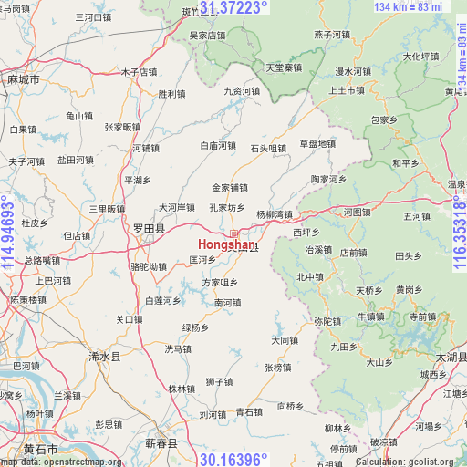
Hongshan GPS coordinates[2]
30° 46' 11.964" North, 115° 39' 0.18" East
| Map corner | latitude | longitude |
|---|---|---|
| Upper-left | 31.37223°, | 114.94693° |
| Center: | 30.76999°, | 115.65005° |
| Lower-right: | 30.16396°, | 116.35318° |
| Map W x H: | 134.3×134.3 km | = 83.5×83.5mi |
| max Lat: | 53.31946° ⇑47.3% North |
| Hongshan: | 30.76999° |
| min Lat: | ⇓52.7% South 18.22056° |
| min Long | Hongshan | max Long |
| 75.07348° | 115.65005° | 134.28917° |
| W 57.8%⇐ | ⇒42.2% E |
Elevation
Elevation of Hongshan is 138 m = 453 ft, and this is 346.8 m = 1138 ft below average elevation for this country.
| Max E: |
5622 m = 18445 ft | 53.8% |
| Avg. | 484.8 m = 1591 ft | |
| Hongshan | 138 m = 453 ft | |
Min E: |
-3 m = -10 ft | 46.2% |
See also: China elevation on elevation.city.
Geographical zone
Hongshan is located in North temperate zone (between Tropic of Cancer and the Arctic Circle). Distance of this Northern Tropic circle is 815.4 km =506.7 mi to South.| Distance of | km | miles | from Hongshan |
|---|---|---|---|
| North Pole | 6585.8 | 4092.2 | to North |
| Arctic Circle | 3979.9 | 2473 | to North |
| Tropic Cancer | 815.4 | 506.7 | to South |
| Equator | 3421.3 | 2125.9 | to South |


Nearby cities:
15 places around Hongshan: (largest is in red/bold)
• Bailian
27.8 km =17.3 mi,  225°
225°
• Baimiaohe
26.1 km =16.2 mi,  349°
349°
• Dahe’an
18.3 km =11.4 mi,  295°
295°
• Fangjiazui
14.4 km =8.9 mi,  196°
196°
• Fengshan
24.7 km =15.3 mi,  274°
274°
• Fengshan
25.5 km =15.8 mi, 300°
• Jinjiapu
13.6 km =8.5 mi, 354°
• Kongjiafang
8 km =5 mi, 345°
• Kuanghe
11.6 km =7.2 mi, 231°
• Leijiadian
16.2 km =10.1 mi,  36°
36°
• Luotuo’ao
26.3 km =16.3 mi,  249°
249°
• Nanhe
19.7 km =12.2 mi,  185°
185°
• Shitouzui
26.7 km =16.6 mi,  21°
21°
• Wenquan
10 km =6.2 mi,  27°
27°
• Yangliuwan
12.9 km =8 mi,  63°
63°
Sources, notices
• [Note1] Compared only with cities in China existing in our database
• [Src1] Map data: © OpenStreetMap contributors (CC-BY-SA)
• [Src2] Other city data from geonames.org with taken over terms of usage.
• [Src3] Geographical zone / Annual Mean Temperature by Robert A. Rohde @ Wikipedia
