Fangcheng Chengguanzhen geodata
Fangcheng Chengguanzhen (Henan) is a seat of a third-order administrative division; located in China in Asia/Shanghai (GMT+8) time zone. In our database, there are 1268 cities with bigger population. Compared to other cities in China, 67.2% of cities are located further ↓South; 57.6% of cities are located further →East and 50.8% of cities have higher elevation than Fangcheng Chengguanzhen. Note1
Current local time in Fangcheng Chengguanzhen:
04:31 PM, TuesdayDifference from your time zone: hours


Fangcheng Chengguanzhen GPS coordinates[2]
33° 15' 11.592" North, 113° 0' 4.32" East
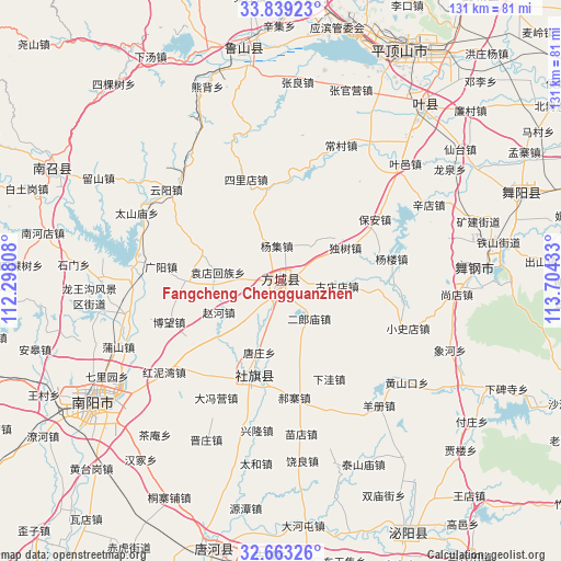
| Map corner | latitude | longitude |
|---|---|---|
| Upper-left | 33.83923°, | 112.29808° |
| Center: | 33.25322°, | 113.0012° |
| Lower-right: | 32.66326°, | 113.70433° |
| Map W x H: | 130.8×130.8 km | = 81.3×81.3mi |
| max Lat: | 53.31946° ⇑32.8% North |
| Fangcheng Chengguanzhen: | 33.25322° |
| min Lat: | ⇓67.2% South 18.22056° |
| min Long | Fangcheng Cheng | max Long |
| 75.07348° | 113.0012° | 134.28917° |
| W 42.4%⇐ | ⇒57.6% E |
Elevation
Elevation of Fangcheng Chengguanzhen is 158 m = 518 ft, and this is 326.8 m = 1072 ft below average elevation for this country.
| Max E: |
5622 m = 18445 ft | 50.8% |
| Avg. | 484.8 m = 1591 ft | |
| Fangcheng Chengguanzhen | 158 m = 518 ft | |
Min E: |
-3 m = -10 ft | 49.2% |
See also: China elevation on elevation.city.
Geographical zone
Fangcheng Chengguanzhen is located in North temperate zone (between Tropic of Cancer and the Arctic Circle). Distance of this Northern Tropic circle is 1091.5 km =678.2 mi to South.| Distance of | km | miles | from Fangcheng Chengguanzhen |
|---|---|---|---|
| North Pole | 6309.7 | 3920.7 | to North |
| Arctic Circle | 3703.8 | 2301.4 | to North |
| Tropic Cancer | 1091.5 | 678.2 | to South |
| Equator | 3697.4 | 2297.5 | to South |


Nearby cities:
15 places around Fangcheng Chengguanzhen: (largest is in red/bold)
• Bao’an
26 km =16.2 mi,  56°
56°
• Bowang
25.4 km =15.8 mi,  249°
249°
• Chengjiao
23.7 km =14.7 mi,  197°
197°
• Dushu
16.8 km =10.4 mi, 61°
• Guangyang
28.1 km =17.5 mi,  277°
277°
• Haozhai
27.3 km =17 mi,  173°
173°
• Liuhe
19.9 km =12.4 mi,  290°
290°
• Qinghe
8.9 km =5.5 mi,  268°
268°
• Shedian
22 km =13.7 mi,  194°
194°
• Silidian
25 km =15.5 mi,  341°
341°
• Tangzhuang
17.4 km =10.8 mi, 196°
• Xuanqiao
11.8 km =7.3 mi, 198°
• Yangji
8.3 km =5.2 mi,  354°
354°
• Yuandianhui
14.8 km =9.2 mi, 278°
• Zhaohe
16.2 km =10.1 mi,  243°
243°
Sources, notices
• [Note1] Compared only with cities in China existing in our database
• [Src1] Map data: © OpenStreetMap contributors (CC-BY-SA)
• [Src2] Other city data from geonames.org with taken over terms of usage.
• [Src3] Geographical zone / Annual Mean Temperature by Robert A. Rohde @ Wikipedia
