Bao’an geodata
Bao’an (Henan) is a seat of a fourth-order administrative division; located in China in Asia/Shanghai (GMT+8) time zone. In our database, there are 1268 cities with bigger population. Compared to other cities in China, 67.7% of cities are located further ↓South; 56% of cities are located further →East and 51.9% of cities have higher elevation than Bao’an. Note1


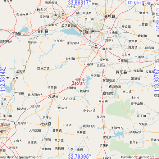
Bao’an GPS coordinates[2]
33° 22' 58.944" North, 113° 14' 4.344" East
| Map corner | latitude | longitude |
|---|---|---|
| Upper-left | 33.96817°, | 112.53142° |
| Center: | 33.38304°, | 113.23454° |
| Lower-right: | 32.79395°, | 113.93767° |
| Map W x H: | 130.6×130.6 km | = 81.2×81.2mi |
| max Lat: | 53.31946° ⇑32.3% North |
| Bao’an: | 33.38304° |
| min Lat: | ⇓67.7% South 18.22056° |
| min Long | Bao’an | max Long |
| 75.07348° | 113.23454° | 134.28917° |
| W 44%⇐ | ⇒56% E |
Elevation
Elevation of Bao’an is 150 m = 492 ft, and this is 334.8 m = 1098 ft below average elevation for this country.
| Max E: |
5622 m = 18445 ft | 51.9% |
| Avg. | 484.8 m = 1591 ft | |
| Bao’an | 150 m = 492 ft | |
Min E: |
-3 m = -10 ft | 48.1% |
See also: China elevation on elevation.city.
Geographical zone
Bao’an is located in North temperate zone (between Tropic of Cancer and the Arctic Circle). Distance of this Northern Tropic circle is 1105.9 km =687.2 mi to South.| Distance of | km | miles | from Bao’an |
|---|---|---|---|
| North Pole | 6295.2 | 3911.7 | to North |
| Arctic Circle | 3689.3 | 2292.4 | to North |
| Tropic Cancer | 1105.9 | 687.2 | to South |
| Equator | 3711.8 | 2306.4 | to South |


Nearby cities:
15 places around Bao’an: (largest is in red/bold)
• Changcun
19.7 km =12.2 mi,  327°
327°
• Dushu
9.5 km =5.9 mi,  227°
227°
• Fangcheng Chengguanzhen
26 km =16.2 mi,  236°
236°
• Jiuxian
13.9 km =8.6 mi,  25°
25°
• Kuangshan
24.3 km =15.1 mi,  91°
91°
• Longquan
21.2 km =13.2 mi,  56°
56°
• Mazhuang
25.2 km =15.7 mi,  23°
23°
• Miaojie
21.5 km =13.4 mi,  97°
97°
• Shangdian
26.1 km =16.2 mi,  130°
130°
• Tianzhuang
23.3 km =14.5 mi, 28°
• Xiali
16.6 km =10.3 mi,  352°
352°
• Xiantai
25.9 km =16.1 mi,  50°
50°
• Xindian
13.2 km =8.2 mi,  75°
75°
• Yangji
23.3 km =14.5 mi,  254°
254°
• Yuanling
23.7 km =14.7 mi,  118°
118°
Sources, notices
• [Note1] Compared only with cities in China existing in our database
• [Src1] Map data: © OpenStreetMap contributors (CC-BY-SA)
• [Src2] Other city data from geonames.org with taken over terms of usage.
• [Src3] Geographical zone / Annual Mean Temperature by Robert A. Rohde @ Wikipedia
