Yuandianhui geodata
Yuandianhui (Henan) is a seat of a fourth-order administrative division; located in China in Asia/Shanghai (GMT+8) time zone. In our database, there are 1268 cities with bigger population. Compared to other cities in China, 67.3% of cities are located further ↓South; 58.5% of cities are located further →East and 50.2% of cities have lower elevation than Yuandianhui. Note1


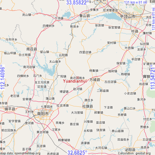
Yuandianhui GPS coordinates[2]
33° 16' 20.424" North, 112° 50' 38.688" East
| Map corner | latitude | longitude |
|---|---|---|
| Upper-left | 33.85822°, | 112.14096° |
| Center: | 33.27234°, | 112.84408° |
| Lower-right: | 32.6825°, | 113.54721° |
| Map W x H: | 130.7×130.7 km | = 81.2×81.2mi |
| max Lat: | 53.31946° ⇑32.7% North |
| Yuandianhui: | 33.27234° |
| min Lat: | ⇓67.3% South 18.22056° |
| min Long | Yuandianhui | max Long |
| 75.07348° | 112.84408° | 134.28917° |
| W 41.5%⇐ | ⇒58.5% E |
Elevation
Elevation of Yuandianhui is 167 m = 548 ft, and this is 317.8 m = 1043 ft below average elevation for this country.
| Max E: |
5622 m = 18445 ft | 49.8% |
| Avg. | 484.8 m = 1591 ft | |
| Yuandianhui | 167 m = 548 ft | |
Min E: |
-3 m = -10 ft | 50.2% |
See also: China elevation on elevation.city.
Geographical zone
Yuandianhui is located in North temperate zone (between Tropic of Cancer and the Arctic Circle). Distance of this Northern Tropic circle is 1093.6 km =679.5 mi to South.| Distance of | km | miles | from Yuandianhui |
|---|---|---|---|
| North Pole | 6307.5 | 3919.3 | to North |
| Arctic Circle | 3701.6 | 2300.1 | to North |
| Tropic Cancer | 1093.6 | 679.5 | to South |
| Equator | 3699.5 | 2298.8 | to South |


Nearby cities:
15 places around Yuandianhui: (largest is in red/bold)
• Bowang
14.3 km =8.9 mi,  220°
220°
• Fangcheng Chengguanzhen
14.8 km =9.2 mi,  98°
98°
• Guangyang
13.3 km =8.3 mi,  275°
275°
• Huanghou
24.5 km =15.2 mi,  340°
340°
• Huangludian
19.5 km =12.1 mi,  264°
264°
• Liuhe
6.4 km =4 mi,  320°
320°
• Qiaotou
24.4 km =15.2 mi,  187°
187°
• Qinghe
6.2 km =3.9 mi,  112°
112°
• Silidian
22.6 km =14 mi,  17°
17°
• Taishanmiao
23.2 km =14.4 mi,  306°
306°
• Tangzhuang
21.1 km =13.1 mi,  152°
152°
• Xuanqiao
17.2 km =10.7 mi,  140°
140°
• Yangji
15.1 km =9.4 mi,  66°
66°
• Yunyang
22.9 km =14.2 mi,  328°
328°
• Zhaohe
9.4 km =5.8 mi,  179°
179°
Sources, notices
• [Note1] Compared only with cities in China existing in our database
• [Src1] Map data: © OpenStreetMap contributors (CC-BY-SA)
• [Src2] Other city data from geonames.org with taken over terms of usage.
• [Src3] Geographical zone / Annual Mean Temperature by Robert A. Rohde @ Wikipedia
