Dongsheng geodata
Dongsheng (Inner Mongolia) is a populated place; located in China in Asia/Shanghai (GMT+8) time zone. With population of 99,809 people, there are 427 cities with bigger population in this country. Compared to other cities in China, 85.8% of cities are located further ↓South; 71.3% of cities are located further →East and 90.9% of cities have lower elevation than Dongsheng. Note1


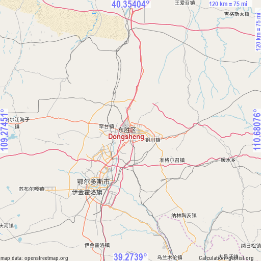
Dongsheng GPS coordinates[2]
39° 48' 57.924" North, 109° 58' 39.468" East
| Map corner | latitude | longitude |
|---|---|---|
| Upper-left | 40.35404°, | 109.27451° |
| Center: | 39.81609°, | 109.97763° |
| Lower-right: | 39.2739°, | 110.68076° |
| Map W x H: | 120.1×120.1 km | = 74.6×74.6mi |
| max Lat: | 53.31946° ⇑14.2% North |
| Dongsheng: | 39.81609° |
| min Lat: | ⇓85.8% South 18.22056° |
| min Long | Dongsheng | max Long |
| 75.07348° | 109.97763° | 134.28917° |
| W 28.7%⇐ | ⇒71.3% E |
Elevation
Elevation of Dongsheng is 1439 m = 4721 ft, and this is 954.2 m = 3131 ft above average elevation for this country.
| Max E: |
5622 m = 18445 ft | 9.1% |
| Dongsheng | 1439 m 4721 ft | |
| Avg. | 484.8 m = 1591 ft | |
Min E: |
-3 m = -10 ft | 90.9% |
See also: Dongsheng elevation on elevation.city.
Geographical zone
Dongsheng is located in North temperate zone (between Tropic of Cancer and the Arctic Circle). Distance of this Northern Tropic circle is 1821.2 km =1131.6 mi to South.| Distance of | km | miles | from Dongsheng |
|---|---|---|---|
| North Pole | 5579.9 | 3467.2 | to North |
| Arctic Circle | 2974 | 1848 | to North |
| Tropic Cancer | 1821.2 | 1131.6 | to South |
| Equator | 4427.1 | 2750.9 | to South |


Nearby cities:
15 places around Dongsheng: (largest is in red/bold)
• Aletengxire
32.3 km =20.1 mi,  215°
215°
• Altan Xiret
32.8 km =20.4 mi, 215°
• Baotou
93.9 km =58.3 mi,  351°
351°
• Hujigou
114.5 km =71.1 mi,  3°
3°
• Jihuluntu Sumu
111.3 km =69.2 mi,  14°
14°
• Lamawan
123.1 km =76.5 mi,  76°
76°
• Ordos
28.5 km =17.7 mi, 216°
• Salaqi
92.5 km =57.5 mi,  29°
29°
• Shagedu
77.7 km =48.3 mi,  103°
103°
• Shiguai
102.3 km =63.6 mi, 14°
• Shulinzhao
64.3 km =40 mi, 3°
• Tianjiao
2.1 km =1.3 mi,  60°
60°
• Wenbi
114.4 km =71.1 mi,  114°
114°
• Xinli
106.2 km =66 mi,  271°
271°
• Xuejiawan
106.3 km =66.1 mi,  86°
86°
Sources, notices
• [Note1] Compared only with cities in China existing in our database
• [Src1] Map data: © OpenStreetMap contributors (CC-BY-SA)
• [Src2] Other city data from geonames.org with taken over terms of usage.
• [Src3] Geographical zone / Annual Mean Temperature by Robert A. Rohde @ Wikipedia
