Ordos geodata
Ordos (Inner Mongolia) is a populated place; located in China in Asia/Shanghai (GMT+8) time zone. With population of 1,940,653 people, there are 43 cities with bigger population in this country. Compared to other cities in China, 84.9% of cities are located further ↓South; 72.3% of cities are located further →East and 89.5% of cities have lower elevation than Ordos. Note1


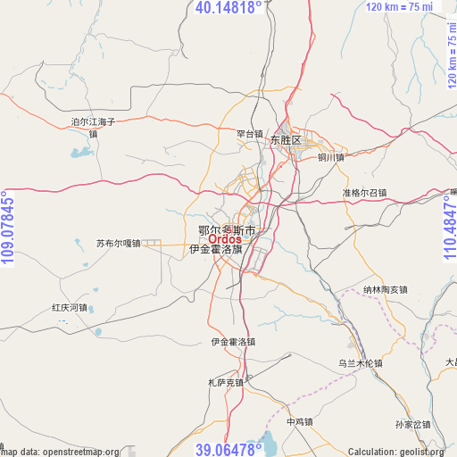
Ordos GPS coordinates[2]
39° 36' 30.96" North, 109° 46' 53.652" East
| Map corner | latitude | longitude |
|---|---|---|
| Upper-left | 40.14818°, | 109.07845° |
| Center: | 39.6086°, | 109.78157° |
| Lower-right: | 39.06478°, | 110.4847° |
| Map W x H: | 120.5×120.5 km | = 74.9×74.9mi |
| max Lat: | 53.31946° ⇑15.1% North |
| Ordos: | 39.6086° |
| min Lat: | ⇓84.9% South 18.22056° |
| min Long | Ordos | max Long |
| 75.07348° | 109.78157° | 134.28917° |
| W 27.7%⇐ | ⇒72.3% E |
Elevation
Elevation of Ordos is 1310 m = 4298 ft, and this is 825.2 m = 2707 ft above average elevation for this country.
| Max E: |
5622 m = 18445 ft | 10.5% |
| Ordos | 1310 m 4298 ft | |
| Avg. | 484.8 m = 1591 ft | |
Min E: |
-3 m = -10 ft | 89.5% |
See also: Ordos elevation on elevation.city.
Geographical zone
Ordos is located in North temperate zone (between Tropic of Cancer and the Arctic Circle). Distance of this Northern Tropic circle is 1798.1 km =1117.3 mi to South.| Distance of | km | miles | from Ordos |
|---|---|---|---|
| North Pole | 5603 | 3481.5 | to North |
| Arctic Circle | 2997.1 | 1862.3 | to North |
| Tropic Cancer | 1798.1 | 1117.3 | to South |
| Equator | 4404.1 | 2736.6 | to South |


Nearby cities:
15 places around Ordos: (largest is in red/bold)
• Aletengxire
3.8 km =2.4 mi,  212°
212°
• Altan Xiret
4.3 km =2.7 mi,  215°
215°
• Baotou
116.1 km =72.1 mi,  1°
1°
• Dongguan
133.1 km =82.7 mi,  119°
119°
• Dongsheng
28.5 km =17.7 mi,  36°
36°
• Galutu
138 km =85.7 mi, 215°
• Jihuluntu Sumu
138.3 km =85.9 mi,  18°
18°
• Salaqi
120.9 km =75.1 mi,  30°
30°
• Shagedu
92.4 km =57.4 mi,  87°
87°
• Shiguai
129.3 km =80.3 mi, 19°
• Shulinzhao
89.7 km =55.7 mi,  13°
13°
• Tianjiao
30.5 km =19 mi, 37°
• Wenbi
123.4 km =76.7 mi,  101°
101°
• Xinli
93.3 km =58 mi,  286°
286°
• Xuejiawan
126.4 km =78.5 mi,  76°
76°
Sources, notices
• [Note1] Compared only with cities in China existing in our database
• [Src1] Map data: © OpenStreetMap contributors (CC-BY-SA)
• [Src2] Other city data from geonames.org with taken over terms of usage.
• [Src3] Geographical zone / Annual Mean Temperature by Robert A. Rohde @ Wikipedia
