Debao Chengguanzhen geodata
Debao Chengguanzhen (Guangxi) is a seat of a third-order administrative division; located in China in Asia/Shanghai (GMT+8) time zone. In our database, there are 1268 cities with bigger population. Compared to other cities in China, 92.7% of cities are located further ↑North; 84.9% of cities are located further →East and 79.9% of cities have lower elevation than Debao Chengguanzhen. Note1


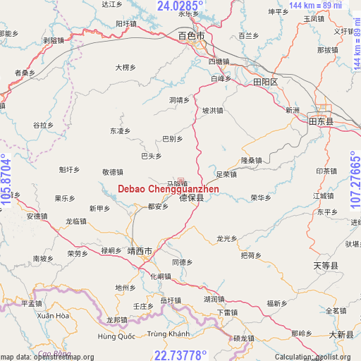
Debao Chengguanzhen GPS coordinates[2]
23° 23' 4.956" North, 106° 34' 24.672" East
| Map corner | latitude | longitude |
|---|---|---|
| Upper-left | 24.0285°, | 105.8704° |
| Center: | 23.38471°, | 106.57352° |
| Lower-right: | 22.73778°, | 107.27665° |
| Map W x H: | 143.5×143.5 km | = 89.2×89.2mi |
| max Lat: | 53.31946° ⇑92.7% North |
| Debao Chengguanzhen: | 23.38471° |
| min Lat: | ⇓7.3% South 18.22056° |
| min Long | Debao Chengguan | max Long |
| 75.07348° | 106.57352° | 134.28917° |
| W 15.1%⇐ | ⇒84.9% E |
Elevation
Elevation of Debao Chengguanzhen is 688 m = 2257 ft, and this is 203.2 m = 667 ft above average elevation for this country.
| Max E: |
5622 m = 18445 ft | 20.1% |
| Debao Chengguanzhen | 688 m 2257 ft | |
| Avg. | 484.8 m = 1591 ft | |
Min E: |
-3 m = -10 ft | 79.9% |
See also: China elevation on elevation.city.
Geographical zone
Debao Chengguanzhen is located in North Torrid zone (between Equator and Tropic of Cancer). Distance of this Northern Tropic circle is 5.8 km =3.6 mi to North.| Distance of | km | miles | from Debao Chengguanzhen |
|---|---|---|---|
| North Pole | 7406.9 | 4602.4 | to North |
| Arctic Circle | 4801 | 2983.2 | to North |
| Tropic Cancer | 5.8 | 3.6 | to North |
| Equator | 2600.1 | 1615.6 | to South |


Nearby cities:
15 places around Debao Chengguanzhen: (largest is in red/bold)
• Baise City
57.4 km =35.7 mi,  4°
4°
• Bama
111.2 km =69.1 mi,  38°
38°
• Fengcheng
140.3 km =87.2 mi,  19°
19°
• Leli
112.9 km =70.2 mi,  342°
342°
• Longzhou
111.7 km =69.4 mi,  168°
168°
• Long’an Chengxiangzhen
111.8 km =69.5 mi,  100°
100°
• Matou
100.4 km =62.4 mi,  91°
91°
• Napo Chengxiangzhen
80.5 km =50 mi,  277°
277°
• Pingma
60.7 km =37.7 mi,  62°
62°
• Sicheng
113.5 km =70.5 mi, 0°
• Taocheng
81.9 km =50.9 mi,  133°
133°
• Tiandeng
60.4 km =37.5 mi,  118°
118°
• Tianzhou
54.8 km =34.1 mi, 36°
• Xinhua
98.1 km =61 mi,  287°
287°
• Xinjing
28.2 km =17.5 mi,  223°
223°
Sources, notices
• [Note1] Compared only with cities in China existing in our database
• [Src1] Map data: © OpenStreetMap contributors (CC-BY-SA)
• [Src2] Other city data from geonames.org with taken over terms of usage.
• [Src3] Geographical zone / Annual Mean Temperature by Robert A. Rohde @ Wikipedia
