Bama geodata
Bama (Guangxi) is a seat of a third-order administrative division; located in China in Asia/Shanghai (GMT+8) time zone. In our database, there are 1268 cities with bigger population. Compared to other cities in China, 89.7% of cities are located further ↑North; 82.9% of cities are located further →East and 60.5% of cities have lower elevation than Bama. Note1


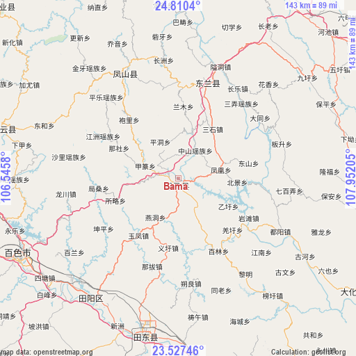
Bama GPS coordinates[2]
24° 10' 13.944" North, 107° 14' 56.112" East
| Map corner | latitude | longitude |
|---|---|---|
| Upper-left | 24.8104°, | 106.5458° |
| Center: | 24.17054°, | 107.24892° |
| Lower-right: | 23.52746°, | 107.95205° |
| Map W x H: | 142.6×142.7 km | = 88.6×88.7mi |
| max Lat: | 53.31946° ⇑89.7% North |
| Bama: | 24.17054° |
| min Lat: | ⇓10.3% South 18.22056° |
| min Long | Bama | max Long |
| 75.07348° | 107.24892° | 134.28917° |
| W 17.1%⇐ | ⇒82.9% E |
Elevation
Elevation of Bama is 266 m = 873 ft, and this is 218.8 m = 718 ft below average elevation for this country.
| Max E: |
5622 m = 18445 ft | 39.5% |
| Avg. | 484.8 m = 1591 ft | |
| Bama | 266 m = 873 ft | |
Min E: |
-3 m = -10 ft | 60.5% |
See also: China elevation on elevation.city.
Geographical zone
Bama is located in North temperate zone (between Tropic of Cancer and the Arctic Circle). Distance of this Northern Tropic circle is 81.6 km =50.7 mi to South.| Distance of | km | miles | from Bama |
|---|---|---|---|
| North Pole | 7319.5 | 4548.1 | to North |
| Arctic Circle | 4713.7 | 2929 | to North |
| Tropic Cancer | 81.6 | 50.7 | to South |
| Equator | 2687.5 | 1669.9 | to South |


Nearby cities:
15 places around Bama: (largest is in red/bold)
• Anyang
90 km =55.9 mi,  106°
106°
• Baise City
71.2 km =44.2 mi,  244°
244°
• Baishan
106.6 km =66.2 mi,  118°
118°
• Dahua
87.1 km =54.1 mi, 120°
• Debao Chengguanzhen
111.2 km =69.1 mi,  218°
218°
• Donglan
44.3 km =27.5 mi,  17°
17°
• Fengcheng
49.2 km =30.6 mi,  334°
334°
• Leli
103.9 km =64.6 mi,  281°
281°
• Liupai
97 km =60.3 mi,  355°
355°
• Matou
95.9 km =59.6 mi,  160°
160°
• Nandan Chengguanzhen
98.4 km =61.1 mi, 18°
• Pingma
61.1 km =38 mi,  194°
194°
• Sicheng
72.5 km =45 mi,  291°
291°
• Tianzhou
56.4 km =35 mi, 219°
• Tongle
101.5 km =63.1 mi,  317°
317°
Sources, notices
• [Note1] Compared only with cities in China existing in our database
• [Src1] Map data: © OpenStreetMap contributors (CC-BY-SA)
• [Src2] Other city data from geonames.org with taken over terms of usage.
• [Src3] Geographical zone / Annual Mean Temperature by Robert A. Rohde @ Wikipedia
