Baise City geodata
Baise City (Guangxi) is a seat of a second-order administrative division; located in China in Asia/Shanghai (GMT+8) time zone. With population of 90,603 people, there are 469 cities with bigger population in this country. Compared to other cities in China, 90.7% of cities are located further ↑North; 84.8% of cities are located further →East and 54.2% of cities have higher elevation than Baise City. Note1


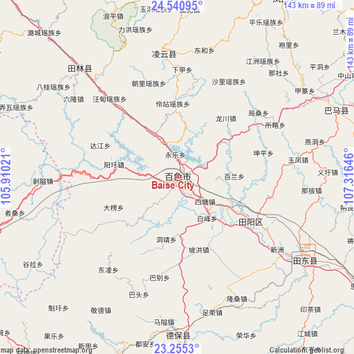
Baise City GPS coordinates[2]
23° 53' 58.992" North, 106° 36' 47.988" East
| Map corner | latitude | longitude |
|---|---|---|
| Upper-left | 24.54095°, | 105.91021° |
| Center: | 23.89972°, | 106.61333° |
| Lower-right: | 23.2553°, | 107.31646° |
| Map W x H: | 143×143 km | = 88.9×88.9mi |
| max Lat: | 53.31946° ⇑90.7% North |
| Baise City: | 23.89972° |
| min Lat: | ⇓9.3% South 18.22056° |
| min Long | Baise City | max Long |
| 75.07348° | 106.61333° | 134.28917° |
| W 15.2%⇐ | ⇒84.8% E |
Elevation
Elevation of Baise City is 136 m = 446 ft, and this is 348.8 m = 1144 ft below average elevation for this country.
| Max E: |
5622 m = 18445 ft | 54.2% |
| Avg. | 484.8 m = 1591 ft | |
| Baise City | 136 m = 446 ft | |
Min E: |
-3 m = -10 ft | 45.8% |
See also: Baise City elevation on elevation.city.
Geographical zone
Baise City is located in North temperate zone (between Tropic of Cancer and the Arctic Circle). Distance of this Northern Tropic circle is 51.5 km =32 mi to South.| Distance of | km | miles | from Baise City |
|---|---|---|---|
| North Pole | 7349.7 | 4566.9 | to North |
| Arctic Circle | 4743.8 | 2947.7 | to North |
| Tropic Cancer | 51.5 | 32 | to South |
| Equator | 2657.4 | 1651.2 | to South |


Nearby cities:
15 places around Baise City: (largest is in red/bold)
• Bama
71.2 km =44.2 mi,  64°
64°
• Debao Chengguanzhen
57.4 km =35.7 mi,  184°
184°
• Donglan
106.4 km =66.1 mi,  47°
47°
• Fengcheng
86.4 km =53.7 mi,  30°
30°
• Leli
62.9 km =39.1 mi,  323°
323°
• Matou
113.5 km =70.5 mi,  122°
122°
• Napo Chengxiangzhen
95.8 km =59.5 mi,  240°
240°
• Pingma
57.6 km =35.8 mi, 120°
• Sicheng
56.3 km =35 mi,  356°
356°
• Taocheng
126.3 km =78.5 mi,  153°
153°
• Tiandeng
98.9 km =61.5 mi, 150°
• Tianzhou
31.9 km =19.8 mi, 115°
• Tongle
105.5 km =65.6 mi, 357°
• Xinhua
101.8 km =63.3 mi,  253°
253°
• Xinjing
81 km =50.3 mi,  196°
196°
Sources, notices
• [Note1] Compared only with cities in China existing in our database
• [Src1] Map data: © OpenStreetMap contributors (CC-BY-SA)
• [Src2] Other city data from geonames.org with taken over terms of usage.
• [Src3] Geographical zone / Annual Mean Temperature by Robert A. Rohde @ Wikipedia
