Leli geodata
Leli (Guangxi) is a seat of a third-order administrative division; located in China in Asia/Shanghai (GMT+8) time zone. In our database, there are 1268 cities with bigger population. Compared to other cities in China, 89% of cities are located further ↑North; 86% of cities are located further →East and 77.2% of cities have lower elevation than Leli. Note1


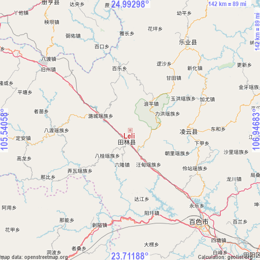
Leli GPS coordinates[2]
24° 21' 14.58" North, 106° 14' 37.32" East
| Map corner | latitude | longitude |
|---|---|---|
| Upper-left | 24.99298°, | 105.54058° |
| Center: | 24.35405°, | 106.2437° |
| Lower-right: | 23.71188°, | 106.94683° |
| Map W x H: | 142.4×142.4 km | = 88.5×88.5mi |
| max Lat: | 53.31946° ⇑89% North |
| Leli: | 24.35405° |
| min Lat: | ⇓11% South 18.22056° |
| min Long | Leli | max Long |
| 75.07348° | 106.2437° | 134.28917° |
| W 14%⇐ | ⇒86% E |
Elevation
Elevation of Leli is 583 m = 1913 ft, and this is 98.2 m = 322 ft above average elevation for this country.
| Max E: |
5622 m = 18445 ft | 22.8% |
| Leli | 583 m 1913 ft | |
| Avg. | 484.8 m = 1591 ft | |
Min E: |
-3 m = -10 ft | 77.2% |
See also: China elevation on elevation.city.
Geographical zone
Leli is located in North temperate zone (between Tropic of Cancer and the Arctic Circle). Distance of this Northern Tropic circle is 102 km =63.4 mi to South.| Distance of | km | miles | from Leli |
|---|---|---|---|
| North Pole | 7299.1 | 4535.4 | to North |
| Arctic Circle | 4693.3 | 2916.3 | to North |
| Tropic Cancer | 102 | 63.4 | to South |
| Equator | 2707.9 | 1682.6 | to South |


Nearby cities:
15 places around Leli: (largest is in red/bold)
• Bada
119.4 km =74.2 mi,  282°
282°
• Baise City
62.9 km =39.1 mi,  143°
143°
• Bama
103.9 km =64.6 mi,  101°
101°
• Debao Chengguanzhen
112.9 km =70.2 mi,  162°
162°
• Donglan
117.3 km =72.9 mi,  79°
79°
• Fengcheng
84.4 km =52.4 mi,  73°
73°
• Liancheng
123.2 km =76.6 mi,  254°
254°
• Liupai
121 km =75.2 mi,  50°
50°
• Napo Chengxiangzhen
107.6 km =66.9 mi,  205°
205°
• Pingma
118.1 km =73.4 mi,  132°
132°
• Sicheng
34.7 km =21.6 mi, 80°
• Tianzhou
92.2 km =57.3 mi, 133°
• Tongle
64.4 km =40 mi,  31°
31°
• Xinhua
99.2 km =61.6 mi,  217°
217°
• Xinzhou
107.1 km =66.5 mi,  302°
302°
Sources, notices
• [Note1] Compared only with cities in China existing in our database
• [Src1] Map data: © OpenStreetMap contributors (CC-BY-SA)
• [Src2] Other city data from geonames.org with taken over terms of usage.
• [Src3] Geographical zone / Annual Mean Temperature by Robert A. Rohde @ Wikipedia
