Xixia geodata
Xixia (Zhejiang) is a seat of a fourth-order administrative division; located in China in Asia/Shanghai (GMT+8) time zone. In our database, there are 1268 cities with bigger population. Compared to other cities in China, 69.7% of cities are located further ↑North; 85% of cities are located further ←West and 71% of cities have lower elevation than Xixia. Note1


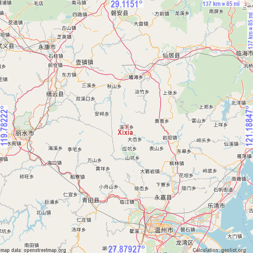
Xixia GPS coordinates[2]
28° 29' 56.364" North, 120° 29' 7.224" East
| Map corner | latitude | longitude |
|---|---|---|
| Upper-left | 29.1151°, | 119.78222° |
| Center: | 28.49899°, | 120.48534° |
| Lower-right: | 27.87927°, | 121.18847° |
| Map W x H: | 137.4×137.4 km | = 85.4×85.4mi |
| max Lat: | 53.31946° ⇑69.7% North |
| Xixia: | 28.49899° |
| min Lat: | ⇓30.3% South 18.22056° |
| min Long | Xixia | max Long |
| 75.07348° | 120.48534° | 134.28917° |
| W 85%⇐ | ⇒15% E |
Elevation
Elevation of Xixia is 429 m = 1407 ft, and this is 55.8 m = 183 ft below average elevation for this country.
| Max E: |
5622 m = 18445 ft | 29% |
| Avg. | 484.8 m = 1591 ft | |
| Xixia | 429 m = 1407 ft | |
Min E: |
-3 m = -10 ft | 71% |
See also: China elevation on elevation.city.
Geographical zone
Xixia is located in North temperate zone (between Tropic of Cancer and the Arctic Circle). Distance of this Northern Tropic circle is 562.9 km =349.8 mi to South.| Distance of | km | miles | from Xixia |
|---|---|---|---|
| North Pole | 6838.3 | 4249.1 | to North |
| Arctic Circle | 4232.4 | 2629.9 | to North |
| Tropic Cancer | 562.9 | 349.8 | to South |
| Equator | 3168.8 | 1969 | to South |


Nearby cities:
15 places around Xixia: (largest is in red/bold)
• Anling
15.3 km =9.5 mi,  298°
298°
• Biaoshan
20 km =12.4 mi,  125°
125°
• Danzhu
21.1 km =13.1 mi,  23°
23°
• Dayuan
20.4 km =12.7 mi,  307°
307°
• Da’ao
8 km =5 mi,  146°
146°
• Huangnan
19.4 km =12.1 mi,  80°
80°
• Jiekeng
9.8 km =6.1 mi,  234°
234°
• Muli
15.2 km =9.4 mi,  248°
248°
• Nanxi
17.3 km =10.7 mi,  268°
268°
• Pankeng
11.1 km =6.9 mi,  117°
117°
• Shankeng
17 km =10.6 mi,  169°
169°
• Shiran
18.1 km =11.2 mi,  204°
204°
• Xi’ao
12.5 km =7.8 mi, 227°
• Xunzhai
16.8 km =10.4 mi,  181°
181°
• Yingkeng
11.8 km =7.3 mi, 172°
Sources, notices
• [Note1] Compared only with cities in China existing in our database
• [Src1] Map data: © OpenStreetMap contributors (CC-BY-SA)
• [Src2] Other city data from geonames.org with taken over terms of usage.
• [Src3] Geographical zone / Annual Mean Temperature by Robert A. Rohde @ Wikipedia
