Dahe geodata
Dahe (Sichuan) is a seat of a fourth-order administrative division; located in China in Asia/Shanghai (GMT+8) time zone. With population of 1,000 people, there are 1171 cities with bigger population in this country. Compared to other cities in China, 62.4% of cities are located further ↓South; 83.9% of cities are located further →East and 75.6% of cities have lower elevation than Dahe. Note1


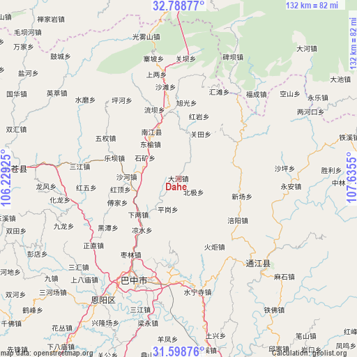
Dahe GPS coordinates[2]
32° 11' 44.556" North, 106° 55' 56.532" East
| Map corner | latitude | longitude |
|---|---|---|
| Upper-left | 32.78877°, | 106.22925° |
| Center: | 32.19571°, | 106.93237° |
| Lower-right: | 31.59876°, | 107.6355° |
| Map W x H: | 132.3×132.3 km | = 82.2×82.2mi |
| max Lat: | 53.31946° ⇑37.6% North |
| Dahe: | 32.19571° |
| min Lat: | ⇓62.4% South 18.22056° |
| min Long | Dahe | max Long |
| 75.07348° | 106.93237° | 134.28917° |
| W 16.1%⇐ | ⇒83.9% E |
Elevation
Elevation of Dahe is 533 m = 1749 ft, and this is 48.2 m = 158 ft above average elevation for this country.
| Max E: |
5622 m = 18445 ft | 24.4% |
| Dahe | 533 m 1749 ft | |
| Avg. | 484.8 m = 1591 ft | |
Min E: |
-3 m = -10 ft | 75.6% |
See also: China elevation on elevation.city.
Geographical zone
Dahe is located in North temperate zone (between Tropic of Cancer and the Arctic Circle). Distance of this Northern Tropic circle is 973.9 km =605.2 mi to South.| Distance of | km | miles | from Dahe |
|---|---|---|---|
| North Pole | 6427.2 | 3993.7 | to North |
| Arctic Circle | 3821.3 | 2374.4 | to North |
| Tropic Cancer | 973.9 | 605.2 | to South |
| Equator | 3579.8 | 2224.4 | to South |


Nearby cities:
15 places around Dahe: (largest is in red/bold)
• Changchi
26.1 km =16.2 mi,  262°
262°
• Chixi
16.5 km =10.3 mi,  253°
253°
• Dongyu
16.7 km =10.4 mi,  320°
320°
• Fujia
24.4 km =15.2 mi, 249°
• Ganchang
23.3 km =14.5 mi,  358°
358°
• Gaoqiao
14.5 km =9 mi,  218°
218°
• Guanlu
16.1 km =10 mi,  14°
14°
• Leba
25.1 km =15.6 mi,  287°
287°
• Nanjiang
19.9 km =12.4 mi,  331°
331°
• Nianpan
20.6 km =12.8 mi,  336°
336°
• Pinggang
12 km =7.5 mi,  200°
200°
• Shahe
19.5 km =12.1 mi,  272°
272°
• Tuanjie
20.8 km =12.9 mi,  299°
299°
• Xialiang
20.1 km =12.5 mi,  228°
228°
• Xingma
6.9 km =4.3 mi,  32°
32°
Sources, notices
• [Note1] Compared only with cities in China existing in our database
• [Src1] Map data: © OpenStreetMap contributors (CC-BY-SA)
• [Src2] Other city data from geonames.org with taken over terms of usage.
• [Src3] Geographical zone / Annual Mean Temperature by Robert A. Rohde @ Wikipedia
