Pinggang geodata
Pinggang (Sichuan) is a seat of a fourth-order administrative division; located in China in Asia/Shanghai (GMT+8) time zone. In our database, there are 1268 cities with bigger population. Compared to other cities in China, 61.8% of cities are located further ↓South; 84% of cities are located further →East and 79.7% of cities have lower elevation than Pinggang. Note1


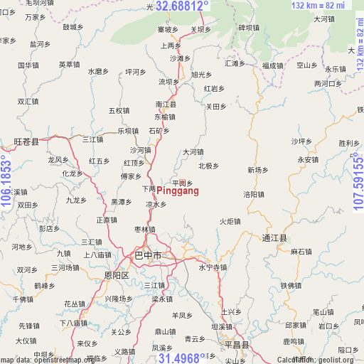
Pinggang GPS coordinates[2]
32° 5' 39.84" North, 106° 53' 18.312" East
| Map corner | latitude | longitude |
|---|---|---|
| Upper-left | 32.68812°, | 106.1853° |
| Center: | 32.0944°, | 106.88842° |
| Lower-right: | 31.4968°, | 107.59155° |
| Map W x H: | 132.5×132.5 km | = 82.3×82.3mi |
| max Lat: | 53.31946° ⇑38.2% North |
| Pinggang: | 32.0944° |
| min Lat: | ⇓61.8% South 18.22056° |
| min Long | Pinggang | max Long |
| 75.07348° | 106.88842° | 134.28917° |
| W 16%⇐ | ⇒84% E |
Elevation
Elevation of Pinggang is 681 m = 2234 ft, and this is 196.2 m = 644 ft above average elevation for this country.
| Max E: |
5622 m = 18445 ft | 20.3% |
| Pinggang | 681 m 2234 ft | |
| Avg. | 484.8 m = 1591 ft | |
Min E: |
-3 m = -10 ft | 79.7% |
See also: China elevation on elevation.city.
Geographical zone
Pinggang is located in North temperate zone (between Tropic of Cancer and the Arctic Circle). Distance of this Northern Tropic circle is 962.6 km =598.1 mi to South.| Distance of | km | miles | from Pinggang |
|---|---|---|---|
| North Pole | 6438.5 | 4000.7 | to North |
| Arctic Circle | 3832.6 | 2381.5 | to North |
| Tropic Cancer | 962.6 | 598.1 | to South |
| Equator | 3568.6 | 2217.4 | to South |


Nearby cities:
15 places around Pinggang: (largest is in red/bold)
• Bazhong
28.5 km =17.7 mi,  208°
208°
• Bazhou
28.7 km =17.8 mi,  202°
202°
• Changchi
23 km =14.3 mi,  289°
289°
• Chixi
13.5 km =8.4 mi,  299°
299°
• Dahe
12 km =7.5 mi,  20°
20°
• Dongyu
25 km =15.5 mi,  345°
345°
• Fujia
18.9 km =11.7 mi,  277°
277°
• Gaoqiao
4.8 km =3 mi,  267°
267°
• Guanlu
28.1 km =17.5 mi, 16°
• Heitan
23.2 km =14.4 mi,  253°
253°
• Leba
27.5 km =17.1 mi,  313°
313°
• Shahe
19.5 km =12.1 mi, 308°
• Tuanjie
25.7 km =16 mi,  327°
327°
• Xialiang
11.2 km =7 mi,  259°
259°
• Xingma
18.8 km =11.7 mi, 24°
Sources, notices
• [Note1] Compared only with cities in China existing in our database
• [Src1] Map data: © OpenStreetMap contributors (CC-BY-SA)
• [Src2] Other city data from geonames.org with taken over terms of usage.
• [Src3] Geographical zone / Annual Mean Temperature by Robert A. Rohde @ Wikipedia
