Langchi geodata
Langchi (Sichuan) is a seat of a third-order administrative division; located in China in Asia/Shanghai (GMT+8) time zone. In our database, there are 1268 cities with bigger population. Compared to other cities in China, 55.4% of cities are located further ↓South; 84.9% of cities are located further →East and 65.5% of cities have lower elevation than Langchi. Note1


Langchi GPS coordinates[2]
31° 4' 46.272" North, 106° 33' 54.504" East
| Map corner | latitude | longitude |
|---|---|---|
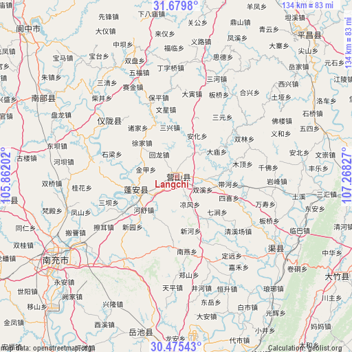
| Upper-left | 31.6798°, | 105.86202° |
| Center: | 31.07952°, | 106.56514° |
| Lower-right: | 30.47543°, | 107.26827° |
| Map W x H: | 133.9×133.9 km | = 83.2×83.2mi |
| max Lat: | 53.31946° ⇑44.6% North |
| Langchi: | 31.07952° |
| min Lat: | ⇓55.4% South 18.22056° |
| min Long | Langchi | max Long |
| 75.07348° | 106.56514° | 134.28917° |
| W 15.1%⇐ | ⇒84.9% E |
Elevation
Elevation of Langchi is 335 m = 1099 ft, and this is 149.8 m = 491 ft below average elevation for this country.
| Max E: |
5622 m = 18445 ft | 34.5% |
| Avg. | 484.8 m = 1591 ft | |
| Langchi | 335 m = 1099 ft | |
Min E: |
-3 m = -10 ft | 65.5% |
See also: China elevation on elevation.city.
Geographical zone
Langchi is located in North temperate zone (between Tropic of Cancer and the Arctic Circle). Distance of this Northern Tropic circle is 849.8 km =528 mi to South.| Distance of | km | miles | from Langchi |
|---|---|---|---|
| North Pole | 6551.3 | 4070.8 | to North |
| Arctic Circle | 3945.5 | 2451.6 | to North |
| Tropic Cancer | 849.8 | 528 | to South |
| Equator | 3455.7 | 2147.3 | to South |


Nearby cities:
15 places around Langchi: (largest is in red/bold)
• Gaoping
55.5 km =34.5 mi,  232°
232°
• Guang’an
67.7 km =42.1 mi,  174°
174°
• Huohua
60 km =37.3 mi, 233°
• Jiangkou
74 km =46 mi,  43°
43°
• Jincheng
65.7 km =40.8 mi,  261°
261°
• Jiulong
61.6 km =38.3 mi,  191°
191°
• Langzhong
75.4 km =46.9 mi,  313°
313°
• Nanchong
55.7 km =34.6 mi,  235°
235°
• Nanlong
56.6 km =35.2 mi,  302°
302°
• Qujiang
46.6 km =29 mi,  124°
124°
• Shuanghejiedao
80.9 km =50.3 mi, 165°
• Xinzheng
34.2 km =21.3 mi, 309°
• Yankou
85.2 km =52.9 mi,  198°
198°
• Zhoukou
16.4 km =10.2 mi,  252°
252°
• Zhuyang
71.7 km =44.6 mi, 122°
Sources, notices
• [Note1] Compared only with cities in China existing in our database
• [Src1] Map data: © OpenStreetMap contributors (CC-BY-SA)
• [Src2] Other city data from geonames.org with taken over terms of usage.
• [Src3] Geographical zone / Annual Mean Temperature by Robert A. Rohde @ Wikipedia
