Huohua geodata
Huohua (Sichuan) is a seat of a third-order administrative division; located in China in Asia/Shanghai (GMT+8) time zone. In our database, there are 1268 cities with bigger population. Compared to other cities in China, 52.6% of cities are located further ↓South; 86.7% of cities are located further →East and 61.5% of cities have lower elevation than Huohua. Note1


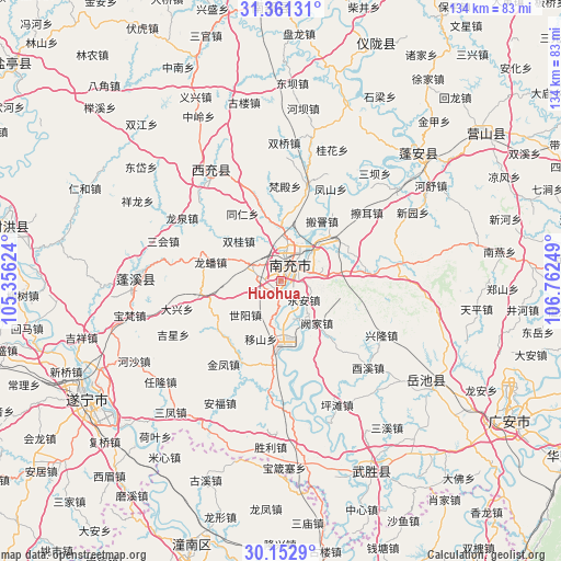
Huohua GPS coordinates[2]
30° 45' 32.4" North, 106° 3' 33.696" East
| Map corner | latitude | longitude |
|---|---|---|
| Upper-left | 31.36131°, | 105.35624° |
| Center: | 30.759°, | 106.05936° |
| Lower-right: | 30.1529°, | 106.76249° |
| Map W x H: | 134.4×134.4 km | = 83.5×83.5mi |
| max Lat: | 53.31946° ⇑47.4% North |
| Huohua: | 30.759° |
| min Lat: | ⇓52.6% South 18.22056° |
| min Long | Huohua | max Long |
| 75.07348° | 106.05936° | 134.28917° |
| W 13.3%⇐ | ⇒86.7% E |
Elevation
Elevation of Huohua is 277 m = 909 ft, and this is 207.8 m = 682 ft below average elevation for this country.
| Max E: |
5622 m = 18445 ft | 38.5% |
| Avg. | 484.8 m = 1591 ft | |
| Huohua | 277 m = 909 ft | |
Min E: |
-3 m = -10 ft | 61.5% |
See also: China elevation on elevation.city.
Geographical zone
Huohua is located in North temperate zone (between Tropic of Cancer and the Arctic Circle). Distance of this Northern Tropic circle is 814.2 km =505.9 mi to South.| Distance of | km | miles | from Huohua |
|---|---|---|---|
| North Pole | 6587 | 4093 | to North |
| Arctic Circle | 3981.1 | 2473.7 | to North |
| Tropic Cancer | 814.2 | 505.9 | to South |
| Equator | 3420.1 | 2125.2 | to South |


Nearby cities:
15 places around Huohua: (largest is in red/bold)
• Baolong
46.9 km =29.1 mi,  196°
196°
• Chicheng
33.2 km =20.6 mi,  273°
273°
• Erlang
44.5 km =27.7 mi,  188°
188°
• Gaoping
4.6 km =2.9 mi,  65°
65°
• Guxi
50.9 km =31.6 mi, 200°
• Jincheng
31.4 km =19.5 mi,  327°
327°
• Jiulong
43.8 km =27.2 mi,  124°
124°
• Longfeng
54.7 km =34 mi,  183°
183°
• Mixin
50.6 km =31.4 mi,  213°
213°
• Nanchong
4.7 km =2.9 mi,  31°
31°
• Qunli
55.2 km =34.3 mi, 202°
• Suining
54.2 km =33.7 mi,  239°
239°
• Yankou
50.3 km =31.3 mi,  154°
154°
• Yanwo
47.5 km =29.5 mi, 178°
• Zhoukou
44.8 km =27.8 mi,  46°
46°
Sources, notices
• [Note1] Compared only with cities in China existing in our database
• [Src1] Map data: © OpenStreetMap contributors (CC-BY-SA)
• [Src2] Other city data from geonames.org with taken over terms of usage.
• [Src3] Geographical zone / Annual Mean Temperature by Robert A. Rohde @ Wikipedia
