Jincheng geodata
Jincheng (Sichuan) is a seat of a third-order administrative division; located in China in Asia/Shanghai (GMT+8) time zone. In our database, there are 1268 cities with bigger population. Compared to other cities in China, 54.8% of cities are located further ↓South; 87.3% of cities are located further →East and 65.3% of cities have lower elevation than Jincheng. Note1


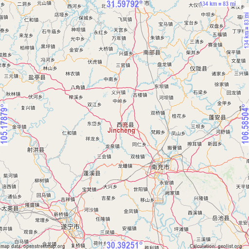
Jincheng GPS coordinates[2]
30° 59' 49.632" North, 105° 52' 54.876" East
| Map corner | latitude | longitude |
|---|---|---|
| Upper-left | 31.59792°, | 105.17879° |
| Center: | 30.99712°, | 105.88191° |
| Lower-right: | 30.39251°, | 106.58504° |
| Map W x H: | 134×134 km | = 83.3×83.3mi |
| max Lat: | 53.31946° ⇑45.2% North |
| Jincheng: | 30.99712° |
| min Lat: | ⇓54.8% South 18.22056° |
| min Long | Jincheng | max Long |
| 75.07348° | 105.88191° | 134.28917° |
| W 12.7%⇐ | ⇒87.3% E |
Elevation
Elevation of Jincheng is 332 m = 1089 ft, and this is 152.8 m = 501 ft below average elevation for this country.
| Max E: |
5622 m = 18445 ft | 34.7% |
| Avg. | 484.8 m = 1591 ft | |
| Jincheng | 332 m = 1089 ft | |
Min E: |
-3 m = -10 ft | 65.3% |
See also: China elevation on elevation.city.
Geographical zone
Jincheng is located in North temperate zone (between Tropic of Cancer and the Arctic Circle). Distance of this Northern Tropic circle is 840.6 km =522.3 mi to South.| Distance of | km | miles | from Jincheng |
|---|---|---|---|
| North Pole | 6560.5 | 4076.5 | to North |
| Arctic Circle | 3954.6 | 2457.3 | to North |
| Tropic Cancer | 840.6 | 522.3 | to South |
| Equator | 3446.6 | 2141.6 | to South |


Nearby cities:
15 places around Jincheng: (largest is in red/bold)
• Baolong
71.5 km =44.4 mi,  177°
177°
• Chicheng
29.1 km =18.1 mi,  213°
213°
• Erlang
71.3 km =44.3 mi,  171°
171°
• Gaoping
32.4 km =20.1 mi,  139°
139°
• Huohua
31.4 km =19.5 mi,  147°
147°
• Langchi
65.7 km =40.8 mi,  81°
81°
• Langzhong
62.4 km =38.8 mi,  9°
9°
• Mixin
69.5 km =43.2 mi,  189°
189°
• Nanchong
29.7 km =18.5 mi, 139°
• Nanlong
43.2 km =26.8 mi,  23°
23°
• Suining
61.9 km =38.5 mi, 208°
• Taihe
49.5 km =30.8 mi,  253°
253°
• Xinzheng
49.4 km =30.7 mi,  51°
51°
• Yunxi
53.6 km =33.3 mi,  298°
298°
• Zhoukou
49.7 km =30.9 mi,  85°
85°
Sources, notices
• [Note1] Compared only with cities in China existing in our database
• [Src1] Map data: © OpenStreetMap contributors (CC-BY-SA)
• [Src2] Other city data from geonames.org with taken over terms of usage.
• [Src3] Geographical zone / Annual Mean Temperature by Robert A. Rohde @ Wikipedia
