Jiantian geodata
Jiantian (Jiangxi) is a seat of a fourth-order administrative division; located in China in Asia/Shanghai (GMT+8) time zone. In our database, there are 1268 cities with bigger population. Compared to other cities in China, 81.2% of cities are located further ↑North; 54.4% of cities are located further ←West and 58.2% of cities have higher elevation than Jiantian. Note1


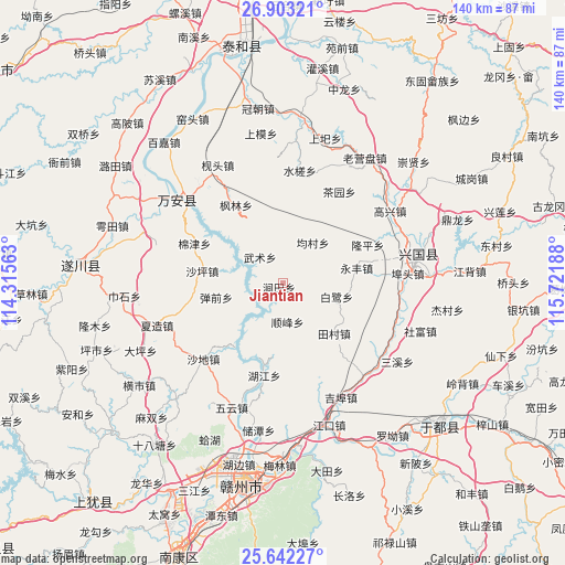
Jiantian GPS coordinates[2]
26° 16' 28.02" North, 115° 1' 7.5" East
| Map corner | latitude | longitude |
|---|---|---|
| Upper-left | 26.90321°, | 114.31563° |
| Center: | 26.27445°, | 115.01875° |
| Lower-right: | 25.64227°, | 115.72188° |
| Map W x H: | 140.2×140.2 km | = 87.1×87.1mi |
| max Lat: | 53.31946° ⇑81.2% North |
| Jiantian: | 26.27445° |
| min Lat: | ⇓18.8% South 18.22056° |
| min Long | Jiantian | max Long |
| 75.07348° | 115.01875° | 134.28917° |
| W 54.4%⇐ | ⇒45.6% E |
Elevation
Elevation of Jiantian is 110 m = 361 ft, and this is 374.8 m = 1230 ft below average elevation for this country.
| Max E: |
5622 m = 18445 ft | 58.2% |
| Avg. | 484.8 m = 1591 ft | |
| Jiantian | 110 m = 361 ft | |
Min E: |
-3 m = -10 ft | 41.8% |
See also: China elevation on elevation.city.
Geographical zone
Jiantian is located in North temperate zone (between Tropic of Cancer and the Arctic Circle). Distance of this Northern Tropic circle is 315.5 km =196 mi to South.| Distance of | km | miles | from Jiantian |
|---|---|---|---|
| North Pole | 7085.6 | 4402.8 | to North |
| Arctic Circle | 4479.7 | 2783.6 | to North |
| Tropic Cancer | 315.5 | 196 | to South |
| Equator | 2921.4 | 1815.3 | to South |


Nearby cities:
15 places around Jiantian: (largest is in red/bold)
• Bailu
13.3 km =8.3 mi,  105°
105°
• Baoshan
8.3 km =5.2 mi,  351°
351°
• Butou
31.8 km =19.8 mi,  86°
86°
• Changgang
36.1 km =22.4 mi,  73°
73°
• Chayuan
26.6 km =16.5 mi,  32°
32°
• Furong
31.8 km =19.8 mi,  307°
307°
• Gaoxing
31.6 km =19.6 mi,  56°
56°
• Jibu
31.4 km =19.5 mi,  153°
153°
• Longkou
29.8 km =18.5 mi, 109°
• Longping
23.4 km =14.5 mi, 67°
• Sanxixiang
34.1 km =21.2 mi,  124°
124°
• Shefu
36.5 km =22.7 mi, 109°
• Shuicha
28 km =17.4 mi,  9°
9°
• Shunfeng
9.6 km =6 mi,  173°
173°
• Yongfeng
19.3 km =12 mi,  79°
79°
Sources, notices
• [Note1] Compared only with cities in China existing in our database
• [Src1] Map data: © OpenStreetMap contributors (CC-BY-SA)
• [Src2] Other city data from geonames.org with taken over terms of usage.
• [Src3] Geographical zone / Annual Mean Temperature by Robert A. Rohde @ Wikipedia
