Baoshan geodata
Baoshan (Jiangxi) is a seat of a fourth-order administrative division; located in China in Asia/Shanghai (GMT+8) time zone. In our database, there are 1268 cities with bigger population. Compared to other cities in China, 81% of cities are located further ↑North; 54.3% of cities are located further ←West and 54.3% of cities have lower elevation than Baoshan. Note1


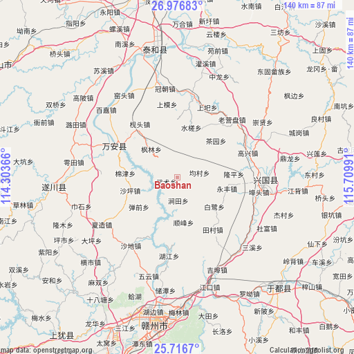
Baoshan GPS coordinates[2]
26° 20' 54.528" North, 115° 0' 24.408" East
| Map corner | latitude | longitude |
|---|---|---|
| Upper-left | 26.97683°, | 114.30366° |
| Center: | 26.34848°, | 115.00678° |
| Lower-right: | 25.7167°, | 115.70991° |
| Map W x H: | 140.1×140.1 km | = 87.1×87.1mi |
| max Lat: | 53.31946° ⇑81% North |
| Baoshan: | 26.34848° |
| min Lat: | ⇓19% South 18.22056° |
| min Long | Baoshan | max Long |
| 75.07348° | 115.00678° | 134.28917° |
| W 54.3%⇐ | ⇒45.7% E |
Elevation
Elevation of Baoshan is 200 m = 656 ft, and this is 284.8 m = 934 ft below average elevation for this country.
| Max E: |
5622 m = 18445 ft | 45.7% |
| Avg. | 484.8 m = 1591 ft | |
| Baoshan | 200 m = 656 ft | |
Min E: |
-3 m = -10 ft | 54.3% |
See also: China elevation on elevation.city.
Geographical zone
Baoshan is located in North temperate zone (between Tropic of Cancer and the Arctic Circle). Distance of this Northern Tropic circle is 323.8 km =201.2 mi to South.| Distance of | km | miles | from Baoshan |
|---|---|---|---|
| North Pole | 7077.4 | 4397.7 | to North |
| Arctic Circle | 4471.5 | 2778.5 | to North |
| Tropic Cancer | 323.8 | 201.2 | to South |
| Equator | 2929.7 | 1820.4 | to South |


Nearby cities:
15 places around Baoshan: (largest is in red/bold)
• Bailu
18.3 km =11.4 mi,  129°
129°
• Butou
33.6 km =20.9 mi,  101°
101°
• Changgang
35.8 km =22.2 mi,  86°
86°
• Chayuan
21 km =13 mi,  46°
46°
• Furong
26.4 km =16.4 mi,  295°
295°
• Gaoxing
29 km =18 mi,  71°
71°
• Jiantian
8.3 km =5.2 mi,  171°
171°
• Jibu
39.4 km =24.5 mi,  157°
157°
• Laoyingpan
31.4 km =19.5 mi,  41°
41°
• Longkou
34.5 km =21.4 mi,  121°
121°
• Longping
22.8 km =14.2 mi, 88°
• Shangyi
30.1 km =18.7 mi,  22°
22°
• Shuicha
20.3 km =12.6 mi, 16°
• Shunfeng
17.9 km =11.1 mi, 172°
• Yongfeng
20.7 km =12.9 mi, 103°
Sources, notices
• [Note1] Compared only with cities in China existing in our database
• [Src1] Map data: © OpenStreetMap contributors (CC-BY-SA)
• [Src2] Other city data from geonames.org with taken over terms of usage.
• [Src3] Geographical zone / Annual Mean Temperature by Robert A. Rohde @ Wikipedia
