Nanhe geodata
Nanhe (Hubei) is a seat of a fourth-order administrative division; located in China in Asia/Shanghai (GMT+8) time zone. In our database, there are 1268 cities with bigger population. Compared to other cities in China, 51.1% of cities are located further ↓South; 57.7% of cities are located further ←West and 57.4% of cities have higher elevation than Nanhe. Note1


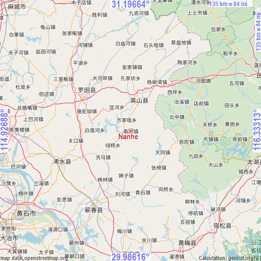
Nanhe GPS coordinates[2]
30° 35' 35.844" North, 115° 37' 48" East
| Map corner | latitude | longitude |
|---|---|---|
| Upper-left | 31.19664°, | 114.92688° |
| Center: | 30.59329°, | 115.63° |
| Lower-right: | 29.98616°, | 116.33313° |
| Map W x H: | 134.6×134.6 km | = 83.6×83.6mi |
| max Lat: | 53.31946° ⇑48.9% North |
| Nanhe: | 30.59329° |
| min Lat: | ⇓51.1% South 18.22056° |
| min Long | Nanhe | max Long |
| 75.07348° | 115.63° | 134.28917° |
| W 57.7%⇐ | ⇒42.3% E |
Elevation
Elevation of Nanhe is 115 m = 377 ft, and this is 369.8 m = 1213 ft below average elevation for this country.
| Max E: |
5622 m = 18445 ft | 57.4% |
| Avg. | 484.8 m = 1591 ft | |
| Nanhe | 115 m = 377 ft | |
Min E: |
-3 m = -10 ft | 42.6% |
See also: China elevation on elevation.city.
Geographical zone
Nanhe is located in North temperate zone (between Tropic of Cancer and the Arctic Circle). Distance of this Northern Tropic circle is 795.7 km =494.4 mi to South.| Distance of | km | miles | from Nanhe |
|---|---|---|---|
| North Pole | 6605.4 | 4104.4 | to North |
| Arctic Circle | 3999.5 | 2485.2 | to North |
| Tropic Cancer | 795.7 | 494.4 | to South |
| Equator | 3401.7 | 2113.7 | to South |


Nearby cities:
15 places around Nanhe: (largest is in red/bold)
• Bailian
18 km =11.2 mi,  270°
270°
• Bailianhe
18.6 km =11.6 mi, 271°
• Caihe
21.6 km =13.4 mi,  261°
261°
• Datong
19.5 km =12.1 mi,  123°
123°
• Fangjiazui
6.2 km =3.9 mi,  339°
339°
• Hongshan
19.7 km =12.2 mi,  5°
5°
• Kongjiafang
27.4 km =17 mi,  359°
359°
• Kuanghe
14.3 km =8.9 mi,  330°
330°
• Luotuo’ao
25 km =15.5 mi,  294°
294°
• Lüyang
11.7 km =7.3 mi,  231°
231°
• Shizi
23 km =14.3 mi,  186°
186°
• Tanlin
22.5 km =14 mi,  110°
110°
• Xima
20.2 km =12.6 mi, 227°
• Zhangbang
23.7 km =14.7 mi,  142°
142°
• Zhulin
28.2 km =17.5 mi,  208°
208°
Sources, notices
• [Note1] Compared only with cities in China existing in our database
• [Src1] Map data: © OpenStreetMap contributors (CC-BY-SA)
• [Src2] Other city data from geonames.org with taken over terms of usage.
• [Src3] Geographical zone / Annual Mean Temperature by Robert A. Rohde @ Wikipedia
