Chezhan geodata
Chezhan (Henan) is a seat of a fourth-order administrative division; located in China in Asia/Shanghai (GMT+8) time zone. In our database, there are 1268 cities with bigger population. Compared to other cities in China, 72.2% of cities are located further ↓South; 60.2% of cities are located further ←West and 70.8% of cities have higher elevation than Chezhan. Note1


Chezhan GPS coordinates[2]
34° 24' 9" North, 116° 1' 27.984" East
| Map corner | latitude | longitude |
|---|---|---|
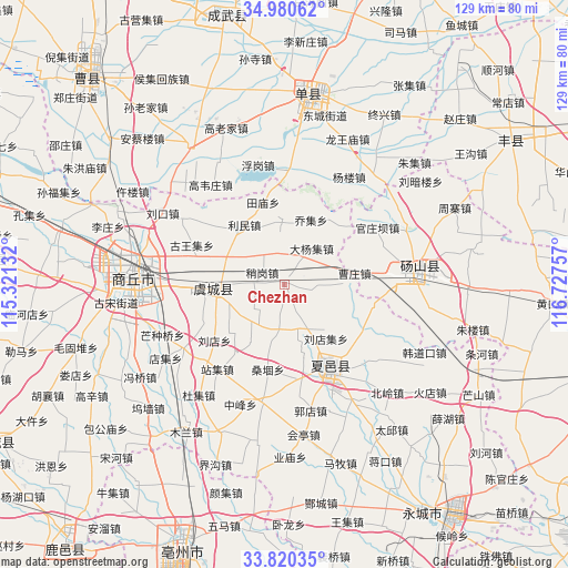
| Upper-left | 34.98062°, | 115.32132° |
| Center: | 34.4025°, | 116.02444° |
| Lower-right: | 33.82035°, | 116.72757° |
| Map W x H: | 129×129 km | = 80.2×80.2mi |
| max Lat: | 53.31946° ⇑27.8% North |
| Chezhan: | 34.4025° |
| min Lat: | ⇓72.2% South 18.22056° |
| min Long | Chezhan | max Long |
| 75.07348° | 116.02444° | 134.28917° |
| W 60.2%⇐ | ⇒39.8% E |
Elevation
Elevation of Chezhan is 49 m = 161 ft, and this is 435.8 m = 1430 ft below average elevation for this country.
| Max E: |
5622 m = 18445 ft | 70.8% |
| Avg. | 484.8 m = 1591 ft | |
| Chezhan | 49 m = 161 ft | |
Min E: |
-3 m = -10 ft | 29.2% |
See also: China elevation on elevation.city.
Geographical zone
Chezhan is located in North temperate zone (between Tropic of Cancer and the Arctic Circle). Distance of this Northern Tropic circle is 1219.3 km =757.6 mi to South.| Distance of | km | miles | from Chezhan |
|---|---|---|---|
| North Pole | 6181.9 | 3841.3 | to North |
| Arctic Circle | 3576 | 2222 | to North |
| Tropic Cancer | 1219.3 | 757.6 | to South |
| Equator | 3825.2 | 2376.9 | to South |


Nearby cities:
15 places around Chezhan: (largest is in red/bold)
• Bozhou
62.9 km =39.1 mi,  201°
201°
• Chengwu
62.7 km =39 mi,  348°
348°
• Dangcheng
32.4 km =20.1 mi,  85°
85°
• Dingtao
85.7 km =53.3 mi,  330°
330°
• Fengxian
61.5 km =38.2 mi,  56°
56°
• Huaibei
85.1 km =52.9 mi,  123°
123°
• Ningling Chengguanzhen
65.1 km =40.5 mi,  274°
274°
• Shancheng
44 km =27.3 mi,  6°
6°
• Shangqiu
34.7 km =21.6 mi,  278°
278°
• Tangzhai
52.1 km =32.4 mi, 86°
• Xiayi Chengguanzhen
20.3 km =12.6 mi,  155°
155°
• Xiguan
78.6 km =48.8 mi,  220°
220°
• Yanji
62.5 km =38.8 mi,  141°
141°
• Yucheng
71.1 km =44.2 mi,  34°
34°
• Zhecheng Chengguanzhen
72.9 km =45.3 mi,  242°
242°
Sources, notices
• [Note1] Compared only with cities in China existing in our database
• [Src1] Map data: © OpenStreetMap contributors (CC-BY-SA)
• [Src2] Other city data from geonames.org with taken over terms of usage.
• [Src3] Geographical zone / Annual Mean Temperature by Robert A. Rohde @ Wikipedia
