Tafang geodata
Tafang (Anhui) is a seat of a fourth-order administrative division; located in China in Asia/Shanghai (GMT+8) time zone. In our database, there are 1268 cities with bigger population. Compared to other cities in China, 56.5% of cities are located further ↑North; 69.3% of cities are located further ←West and 58.2% of cities have higher elevation than Tafang. Note1


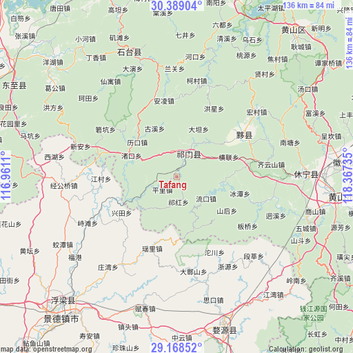
Tafang GPS coordinates[2]
29° 46' 50.304" North, 117° 39' 51.192" East
| Map corner | latitude | longitude |
|---|---|---|
| Upper-left | 30.38904°, | 116.9611° |
| Center: | 29.78064°, | 117.66422° |
| Lower-right: | 29.16852°, | 118.36735° |
| Map W x H: | 135.7×135.7 km | = 84.3×84.3mi |
| max Lat: | 53.31946° ⇑56.5% North |
| Tafang: | 29.78064° |
| min Lat: | ⇓43.5% South 18.22056° |
| min Long | Tafang | max Long |
| 75.07348° | 117.66422° | 134.28917° |
| W 69.3%⇐ | ⇒30.7% E |
Elevation
Elevation of Tafang is 110 m = 361 ft, and this is 374.8 m = 1230 ft below average elevation for this country.
| Max E: |
5622 m = 18445 ft | 58.2% |
| Avg. | 484.8 m = 1591 ft | |
| Tafang | 110 m = 361 ft | |
Min E: |
-3 m = -10 ft | 41.8% |
See also: China elevation on elevation.city.
Geographical zone
Tafang is located in North temperate zone (between Tropic of Cancer and the Arctic Circle). Distance of this Northern Tropic circle is 705.4 km =438.3 mi to South.| Distance of | km | miles | from Tafang |
|---|---|---|---|
| North Pole | 6695.8 | 4160.6 | to North |
| Arctic Circle | 4089.9 | 2541.3 | to North |
| Tropic Cancer | 705.4 | 438.3 | to South |
| Equator | 3311.3 | 2057.5 | to South |


Nearby cities:
15 places around Tafang: (largest is in red/bold)
• Baixi
18.5 km =11.5 mi,  43°
43°
• Datan
20.2 km =12.6 mi,  24°
24°
• Dengta
9.8 km =6.1 mi,  0°
0°
• Hecheng
14.7 km =9.1 mi,  159°
159°
• Jinzipai
15.7 km =9.8 mi,  62°
62°
• Liukou
14.1 km =8.8 mi,  126°
126°
• Luxi
17.3 km =10.7 mi,  241°
241°
• Pingli
7.2 km =4.5 mi,  227°
227°
• Qiaoshan
5.6 km =3.5 mi,  109°
109°
• Qihong
9.5 km =5.9 mi,  177°
177°
• Qishan
8.9 km =5.5 mi, 36°
• Rongkou
12.5 km =7.8 mi,  251°
251°
• Xiaolukou
10.5 km =6.5 mi,  328°
328°
• Xuling
13.7 km =8.5 mi, 24°
• Zhukou
19.2 km =11.9 mi,  295°
295°
Sources, notices
• [Note1] Compared only with cities in China existing in our database
• [Src1] Map data: © OpenStreetMap contributors (CC-BY-SA)
• [Src2] Other city data from geonames.org with taken over terms of usage.
• [Src3] Geographical zone / Annual Mean Temperature by Robert A. Rohde @ Wikipedia
