Qiaoshan geodata
Qiaoshan (Anhui) is a seat of a fourth-order administrative division; located in China in Asia/Shanghai (GMT+8) time zone. In our database, there are 1268 cities with bigger population. Compared to other cities in China, 56.7% of cities are located further ↑North; 69.5% of cities are located further ←West and 52.8% of cities have lower elevation than Qiaoshan. Note1


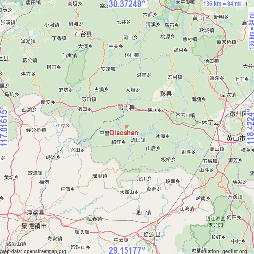
Qiaoshan GPS coordinates[2]
29° 45' 50.364" North, 117° 43' 9.372" East
| Map corner | latitude | longitude |
|---|---|---|
| Upper-left | 30.37249°, | 117.01615° |
| Center: | 29.76399°, | 117.71927° |
| Lower-right: | 29.15177°, | 118.4224° |
| Map W x H: | 135.7×135.7 km | = 84.3×84.3mi |
| max Lat: | 53.31946° ⇑56.7% North |
| Qiaoshan: | 29.76399° |
| min Lat: | ⇓43.3% South 18.22056° |
| min Long | Qiaoshan | max Long |
| 75.07348° | 117.71927° | 134.28917° |
| W 69.5%⇐ | ⇒30.5% E |
Elevation
Elevation of Qiaoshan is 187 m = 614 ft, and this is 297.8 m = 977 ft below average elevation for this country.
| Max E: |
5622 m = 18445 ft | 47.2% |
| Avg. | 484.8 m = 1591 ft | |
| Qiaoshan | 187 m = 614 ft | |
Min E: |
-3 m = -10 ft | 52.8% |
See also: China elevation on elevation.city.
Geographical zone
Qiaoshan is located in North temperate zone (between Tropic of Cancer and the Arctic Circle). Distance of this Northern Tropic circle is 703.5 km =437.1 mi to South.| Distance of | km | miles | from Qiaoshan |
|---|---|---|---|
| North Pole | 6697.6 | 4161.7 | to North |
| Arctic Circle | 4091.7 | 2542.5 | to North |
| Tropic Cancer | 703.5 | 437.1 | to South |
| Equator | 3309.4 | 2056.4 | to South |


Nearby cities:
15 places around Qiaoshan: (largest is in red/bold)
• Baixi
16.9 km =10.5 mi,  26°
26°
• Dengta
12.8 km =8 mi,  336°
336°
• Hecheng
11.9 km =7.4 mi,  180°
180°
• Henglian
17.5 km =10.9 mi,  57°
57°
• Jinzipai
12.5 km =7.8 mi,  43°
43°
• Liukou
8.9 km =5.5 mi,  137°
137°
• Pingli
11.1 km =6.9 mi,  254°
254°
• Qihong
9.1 km =5.7 mi,  212°
212°
• Qishan
8.9 km =5.5 mi,  0°
0°
• Rongkou
17.3 km =10.7 mi,  263°
263°
• Shanhou
18 km =11.2 mi,  129°
129°
• Tafang
5.6 km =3.5 mi,  289°
289°
• Wangcun
17.1 km =10.6 mi,  151°
151°
• Xiaolukou
15.3 km =9.5 mi,  315°
315°
• Xuling
14.3 km =8.9 mi, 1°
Sources, notices
• [Note1] Compared only with cities in China existing in our database
• [Src1] Map data: © OpenStreetMap contributors (CC-BY-SA)
• [Src2] Other city data from geonames.org with taken over terms of usage.
• [Src3] Geographical zone / Annual Mean Temperature by Robert A. Rohde @ Wikipedia
