Wenquan geodata
Wenquan (Hubei) is a seat of a third-order administrative division; located in China in Asia/Shanghai (GMT+8) time zone. In our database, there are 1268 cities with bigger population. Compared to other cities in China, 53.4% of cities are located further ↓South; 58.1% of cities are located further ←West and 71% of cities have lower elevation than Wenquan. Note1


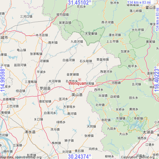
Wenquan GPS coordinates[2]
30° 50' 57.408" North, 115° 41' 56.76" East
| Map corner | latitude | longitude |
|---|---|---|
| Upper-left | 31.45102°, | 114.99598° |
| Center: | 30.84928°, | 115.6991° |
| Lower-right: | 30.24374°, | 116.40223° |
| Map W x H: | 134.2×134.2 km | = 83.4×83.4mi |
| max Lat: | 53.31946° ⇑46.6% North |
| Wenquan: | 30.84928° |
| min Lat: | ⇓53.4% South 18.22056° |
| min Long | Wenquan | max Long |
| 75.07348° | 115.6991° | 134.28917° |
| W 58.1%⇐ | ⇒41.9% E |
Elevation
Elevation of Wenquan is 430 m = 1411 ft, and this is 54.8 m = 180 ft below average elevation for this country.
| Max E: |
5622 m = 18445 ft | 29% |
| Avg. | 484.8 m = 1591 ft | |
| Wenquan | 430 m = 1411 ft | |
Min E: |
-3 m = -10 ft | 71% |
See also: China elevation on elevation.city.
Geographical zone
Wenquan is located in North temperate zone (between Tropic of Cancer and the Arctic Circle). Distance of this Northern Tropic circle is 824.2 km =512.1 mi to South.| Distance of | km | miles | from Wenquan |
|---|---|---|---|
| North Pole | 6576.9 | 4086.7 | to North |
| Arctic Circle | 3971.1 | 2467.5 | to North |
| Tropic Cancer | 824.2 | 512.1 | to South |
| Equator | 3430.1 | 2131.4 | to South |


Nearby cities:
15 places around Wenquan: (largest is in red/bold)
• Baimiaohe
19.3 km =12 mi,  331°
331°
• Caodipan
25.7 km =16 mi,  47°
47°
• Dahe’an
21.2 km =13.2 mi,  267°
267°
• Fangjiazui
24.3 km =15.1 mi,  201°
201°
• Fengshan
26.9 km =16.7 mi,  279°
279°
• Fengshan
30.1 km =18.7 mi,  257°
257°
• Hongshan
10 km =6.2 mi,  207°
207°
• Jinjiapu
7.6 km =4.7 mi,  308°
308°
• Kongjiafang
6.8 km =4.2 mi, 260°
• Kuanghe
21.1 km =13.1 mi,  220°
220°
• Leijiadian
6.5 km =4 mi, 50°
• Nanhe
29.2 km =18.1 mi,  193°
193°
• Shitouzui
16.8 km =10.4 mi,  17°
17°
• Taojiahe
23.6 km =14.7 mi,  72°
72°
• Yangliuwan
7.6 km =4.7 mi,  114°
114°
Sources, notices
• [Note1] Compared only with cities in China existing in our database
• [Src1] Map data: © OpenStreetMap contributors (CC-BY-SA)
• [Src2] Other city data from geonames.org with taken over terms of usage.
• [Src3] Geographical zone / Annual Mean Temperature by Robert A. Rohde @ Wikipedia
