Huanghou geodata
Huanghou (Henan) is a seat of a fourth-order administrative division; located in China in Asia/Shanghai (GMT+8) time zone. In our database, there are 1268 cities with bigger population. Compared to other cities in China, 68% of cities are located further ↓South; 58.9% of cities are located further →East and 57.9% of cities have lower elevation than Huanghou. Note1


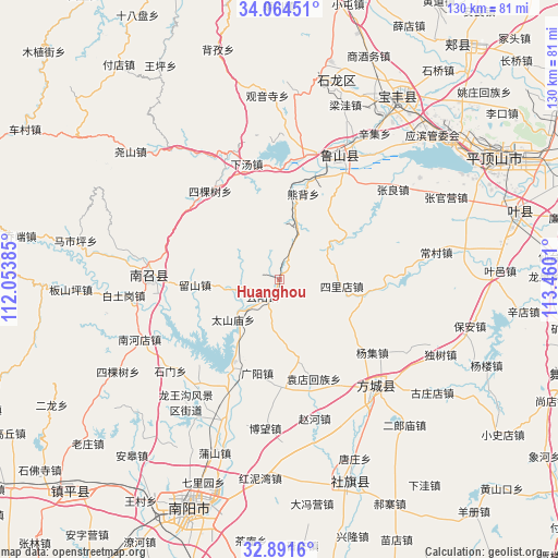
Huanghou GPS coordinates[2]
33° 28' 48.144" North, 112° 45' 25.092" East
| Map corner | latitude | longitude |
|---|---|---|
| Upper-left | 34.06451°, | 112.05385° |
| Center: | 33.48004°, | 112.75697° |
| Lower-right: | 32.8916°, | 113.4601° |
| Map W x H: | 130.4×130.4 km | = 81×81mi |
| max Lat: | 53.31946° ⇑32% North |
| Huanghou: | 33.48004° |
| min Lat: | ⇓68% South 18.22056° |
| min Long | Huanghou | max Long |
| 75.07348° | 112.75697° | 134.28917° |
| W 41.1%⇐ | ⇒58.9% E |
Elevation
Elevation of Huanghou is 235 m = 771 ft, and this is 249.8 m = 820 ft below average elevation for this country.
| Max E: |
5622 m = 18445 ft | 42.1% |
| Avg. | 484.8 m = 1591 ft | |
| Huanghou | 235 m = 771 ft | |
Min E: |
-3 m = -10 ft | 57.9% |
See also: China elevation on elevation.city.
Geographical zone
Huanghou is located in North temperate zone (between Tropic of Cancer and the Arctic Circle). Distance of this Northern Tropic circle is 1116.7 km =693.9 mi to South.| Distance of | km | miles | from Huanghou |
|---|---|---|---|
| North Pole | 6284.4 | 3904.9 | to North |
| Arctic Circle | 3678.5 | 2285.7 | to North |
| Tropic Cancer | 1116.7 | 693.9 | to South |
| Equator | 3722.6 | 2313.1 | to South |


Nearby cities:
15 places around Huanghou: (largest is in red/bold)
• Guangyang
22.4 km =13.9 mi,  193°
193°
• Huangludian
27.3 km =17 mi,  204°
204°
• Jizhong
18.8 km =11.7 mi,  337°
337°
• Liuhe
18.6 km =11.6 mi,  167°
167°
• Liushan
19.6 km =12.2 mi,  267°
267°
• Qinghe
29 km =18 mi,  151°
151°
• Ranghe
25.1 km =15.6 mi,  20°
20°
• Sikeshu
26.1 km =16.2 mi,  322°
322°
• Silidian
14.8 km =9.2 mi,  95°
95°
• Taishanmiao
14.1 km =8.8 mi,  228°
228°
• Xiatang
27.6 km =17.1 mi, 344°
• Xiongbei
20.9 km =13 mi,  14°
14°
• Yangji
27.7 km =17.2 mi,  127°
127°
• Yuandianhui
24.5 km =15.2 mi,  160°
160°
• Yunyang
5.4 km =3.4 mi, 227°
Sources, notices
• [Note1] Compared only with cities in China existing in our database
• [Src1] Map data: © OpenStreetMap contributors (CC-BY-SA)
• [Src2] Other city data from geonames.org with taken over terms of usage.
• [Src3] Geographical zone / Annual Mean Temperature by Robert A. Rohde @ Wikipedia
