Dongzhen geodata
Dongzhen (Guangdong) is a seat of a third-order administrative division; located in China in Asia/Urumqi (GMT+6) time zone. In our database, there are 1268 cities with bigger population. Compared to other cities in China, 96.6% of cities are located further ↑North; 67.2% of cities are located further →East and 61.5% of cities have higher elevation than Dongzhen. Note1


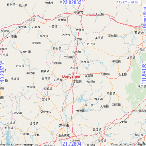
Dongzhen GPS coordinates[2]
22° 22' 46.956" North, 110° 56' 19.86" East
| Map corner | latitude | longitude |
|---|---|---|
| Upper-left | 23.02835°, | 110.23573° |
| Center: | 22.37971°, | 110.93885° |
| Lower-right: | 21.72804°, | 111.64198° |
| Map W x H: | 144.6×144.6 km | = 89.9×89.9mi |
| max Lat: | 53.31946° ⇑96.6% North |
| Dongzhen: | 22.37971° |
| min Lat: | ⇓3.4% South 18.22056° |
| min Long | Dongzhen | max Long |
| 75.07348° | 110.93885° | 134.28917° |
| W 32.8%⇐ | ⇒67.2% E |
Elevation
Elevation of Dongzhen is 90 m = 295 ft, and this is 394.8 m = 1295 ft below average elevation for this country.
| Max E: |
5622 m = 18445 ft | 61.5% |
| Avg. | 484.8 m = 1591 ft | |
| Dongzhen | 90 m = 295 ft | |
Min E: |
-3 m = -10 ft | 38.5% |
See also: China elevation on elevation.city.
Geographical zone
Dongzhen is located in North Torrid zone (between Equator and Tropic of Cancer). Distance of this Northern Tropic circle is 117.5 km =73 mi to North.| Distance of | km | miles | from Dongzhen |
|---|---|---|---|
| North Pole | 7518.7 | 4671.9 | to North |
| Arctic Circle | 4912.8 | 3052.7 | to North |
| Tropic Cancer | 117.5 | 73 | to North |
| Equator | 2488.4 | 1546.2 | to South |


Nearby cities:
15 places around Dongzhen: (largest is in red/bold)
• Baishi
16.1 km =10 mi,  98°
98°
• Beijie
15.9 km =9.9 mi,  244°
244°
• Chashan
28.6 km =17.8 mi,  46°
46°
• Chidong
5.4 km =3.4 mi,  8°
8°
• Dacheng
19.4 km =12.1 mi,  117°
117°
• Dingbao
9.4 km =5.8 mi,  157°
157°
• Dong’an
27.8 km =17.3 mi,  177°
177°
• Hongguan
22.7 km =14.1 mi,  69°
69°
• Jindong
18.7 km =11.6 mi,  299°
299°
• Shenzhen
28.7 km =17.8 mi,  139°
139°
• Shuikou
14.6 km =9.1 mi,  190°
190°
• Tantou
23.3 km =14.5 mi,  201°
201°
• Xinyi
1.2 km =0.7 mi,  129°
129°
• Zhenlong
19.9 km =12.4 mi, 199°
• Zhusha
20.8 km =12.9 mi, 7°
Sources, notices
• [Note1] Compared only with cities in China existing in our database
• [Src1] Map data: © OpenStreetMap contributors (CC-BY-SA)
• [Src2] Other city data from geonames.org with taken over terms of usage.
• [Src3] Geographical zone / Annual Mean Temperature by Robert A. Rohde @ Wikipedia
