Danzao geodata
Danzao (Guangdong) is a seat of a fourth-order administrative division; located in China in Asia/Shanghai (GMT+8) time zone. In our database, there are 1268 cities with bigger population. Compared to other cities in China, 94.3% of cities are located further ↑North; 58% of cities are located further →East and 98.3% of cities have higher elevation than Danzao. Note1


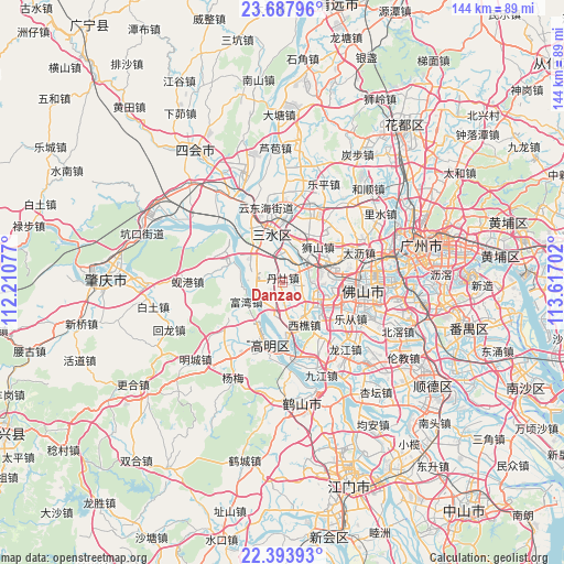
Danzao GPS coordinates[2]
23° 2' 33" North, 112° 54' 50.004" East
| Map corner | latitude | longitude |
|---|---|---|
| Upper-left | 23.68796°, | 112.21077° |
| Center: | 23.0425°, | 112.91389° |
| Lower-right: | 22.39393°, | 113.61702° |
| Map W x H: | 143.9×143.9 km | = 89.4×89.4mi |
| max Lat: | 53.31946° ⇑94.3% North |
| Danzao: | 23.0425° |
| min Lat: | ⇓5.7% South 18.22056° |
| min Long | Danzao | max Long |
| 75.07348° | 112.91389° | 134.28917° |
| W 42%⇐ | ⇒58% E |
Elevation
Elevation of Danzao is 4 m = 13 ft, and this is 480.8 m = 1577 ft below average elevation for this country.
| Max E: |
5622 m = 18445 ft | 98.3% |
| Avg. | 484.8 m = 1591 ft | |
| Danzao | 4 m = 13 ft | |
Min E: |
-3 m = -10 ft | 1.7% |
See also: China elevation on elevation.city.
Geographical zone
Danzao is located in North Torrid zone (between Equator and Tropic of Cancer). Distance of this Northern Tropic circle is 43.8 km =27.2 mi to North.| Distance of | km | miles | from Danzao |
|---|---|---|---|
| North Pole | 7445 | 4626.1 | to North |
| Arctic Circle | 4839.1 | 3006.9 | to North |
| Tropic Cancer | 43.8 | 27.2 | to North |
| Equator | 2562.1 | 1592 | to South |


Nearby cities:
15 places around Danzao: (largest is in red/bold)
• Baini
8.5 km =5.3 mi,  285°
285°
• Foshan
22.3 km =13.9 mi,  94°
94°
• Hecheng
15.6 km =9.7 mi,  190°
190°
• Jinli
14.5 km =9 mi, 286°
• Lecong
19 km =11.8 mi,  119°
119°
• Luocun
12.3 km =7.6 mi,  82°
82°
• Nanzhuang
11 km =6.8 mi, 123°
• Sanshui
12.7 km =7.9 mi,  349°
349°
• Shishan
13.3 km =8.3 mi,  47°
47°
• Shiwan
17.3 km =10.7 mi,  105°
105°
• Xinan
12.6 km =7.8 mi, 350°
• Xinan
16.4 km =10.2 mi,  327°
327°
• Xiqiao
12 km =7.5 mi,  152°
152°
• Zhangcha
16.6 km =10.3 mi, 92°
• Zumiao
22.2 km =13.8 mi, 94°
Sources, notices
• [Note1] Compared only with cities in China existing in our database
• [Src1] Map data: © OpenStreetMap contributors (CC-BY-SA)
• [Src2] Other city data from geonames.org with taken over terms of usage.
• [Src3] Geographical zone / Annual Mean Temperature by Robert A. Rohde @ Wikipedia
