Liyang geodata
Liyang (Zhejiang) is a seat of a fourth-order administrative division; located in China in Asia/Shanghai (GMT+8) time zone. In our database, there are 1268 cities with bigger population. Compared to other cities in China, 59.9% of cities are located further ↑North; 76% of cities are located further ←West and 55% of cities have lower elevation than Liyang. Note1


Liyang GPS coordinates[2]
29° 28' 58.224" North, 118° 59' 33.72" East
| Map corner | latitude | longitude |
|---|---|---|
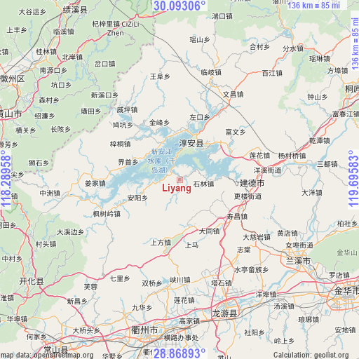
| Upper-left | 30.09306°, | 118.28958° |
| Center: | 29.48284°, | 118.9927° |
| Lower-right: | 28.86893°, | 119.69583° |
| Map W x H: | 136.1×136.1 km | = 84.6×84.6mi |
| max Lat: | 53.31946° ⇑59.9% North |
| Liyang: | 29.48284° |
| min Lat: | ⇓40.1% South 18.22056° |
| min Long | Liyang | max Long |
| 75.07348° | 118.9927° | 134.28917° |
| W 76%⇐ | ⇒24% E |
Elevation
Elevation of Liyang is 206 m = 676 ft, and this is 278.8 m = 915 ft below average elevation for this country.
| Max E: |
5622 m = 18445 ft | 45% |
| Avg. | 484.8 m = 1591 ft | |
| Liyang | 206 m = 676 ft | |
Min E: |
-3 m = -10 ft | 55% |
See also: China elevation on elevation.city.
Geographical zone
Liyang is located in North temperate zone (between Tropic of Cancer and the Arctic Circle). Distance of this Northern Tropic circle is 672.3 km =417.7 mi to South.| Distance of | km | miles | from Liyang |
|---|---|---|---|
| North Pole | 6728.9 | 4181.1 | to North |
| Arctic Circle | 4123 | 2561.9 | to North |
| Tropic Cancer | 672.3 | 417.7 | to South |
| Equator | 3278.2 | 2037 | to South |


Nearby cities:
15 places around Liyang: (largest is in red/bold)
• Anyang
17.4 km =10.8 mi,  246°
246°
• Datong
22.1 km =13.7 mi,  149°
149°
• Dujing
26.5 km =16.5 mi,  299°
299°
• Huipinggeng
29.2 km =18.1 mi,  207°
207°
• Shangfang
24.9 km =15.5 mi,  197°
197°
• Shangma
24.9 km =15.5 mi,  169°
169°
• Shouchang
25.7 km =16 mi,  122°
122°
• Songcun
28.4 km =17.6 mi,  341°
341°
• Tangban
23.6 km =14.7 mi, 341°
• Tongjia
16.5 km =10.3 mi, 117°
• Tongziwu
16.4 km =10.2 mi, 299°
• Wangzhai
24 km =14.9 mi,  4°
4°
• Xin’anjiang
27 km =16.8 mi,  91°
91°
• Yaojia
21.7 km =13.5 mi,  290°
290°
• Zuokou
28.1 km =17.5 mi,  10°
10°
Sources, notices
• [Note1] Compared only with cities in China existing in our database
• [Src1] Map data: © OpenStreetMap contributors (CC-BY-SA)
• [Src2] Other city data from geonames.org with taken over terms of usage.
• [Src3] Geographical zone / Annual Mean Temperature by Robert A. Rohde @ Wikipedia
