Cangshi geodata
Cangshi (Guangdong) is a seat of a fourth-order administrative division; located in China in Asia/Shanghai (GMT+8) time zone. In our database, there are 1268 cities with bigger population. Compared to other cities in China, 85.8% of cities are located further ↑North; 50.2% of cities are located further →East and 51.8% of cities have higher elevation than Cangshi. Note1


Cangshi GPS coordinates[2]
25° 7' 51.708" North, 114° 12' 14.184" East
| Map corner | latitude | longitude |
|---|---|---|
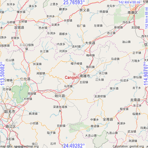
| Upper-left | 25.76593°, | 113.50082° |
| Center: | 25.13103°, | 114.20394° |
| Lower-right: | 24.49282°, | 114.90707° |
| Map W x H: | 141.6×141.6 km | = 88×88mi |
| max Lat: | 53.31946° ⇑85.8% North |
| Cangshi: | 25.13103° |
| min Lat: | ⇓14.2% South 18.22056° |
| min Long | Cangshi | max Long |
| 75.07348° | 114.20394° | 134.28917° |
| W 49.8%⇐ | ⇒50.2% E |
Elevation
Elevation of Cangshi is 151 m = 495 ft, and this is 333.8 m = 1095 ft below average elevation for this country.
| Max E: |
5622 m = 18445 ft | 51.8% |
| Avg. | 484.8 m = 1591 ft | |
| Cangshi | 151 m = 495 ft | |
Min E: |
-3 m = -10 ft | 48.2% |
See also: China elevation on elevation.city.
Geographical zone
Cangshi is located in North temperate zone (between Tropic of Cancer and the Arctic Circle). Distance of this Northern Tropic circle is 188.4 km =117.1 mi to South.| Distance of | km | miles | from Cangshi |
|---|---|---|---|
| North Pole | 7212.8 | 4481.8 | to North |
| Arctic Circle | 4606.9 | 2862.6 | to North |
| Tropic Cancer | 188.4 | 117.1 | to South |
| Equator | 2794.3 | 1736.3 | to South |


Nearby cities:
15 places around Cangshi: (largest is in red/bold)
• Baishun
19 km =11.8 mi,  290°
290°
• Dungang
24.8 km =15.4 mi,  197°
197°
• Gushi
9.5 km =5.9 mi,  151°
151°
• Hukou
20.4 km =12.7 mi,  76°
76°
• Jiangtou
24.8 km =15.4 mi,  101°
101°
• Lanhe
13.1 km =8.1 mi,  330°
330°
• Maozifeng
10.7 km =6.6 mi,  12°
12°
• Mashi
12.6 km =7.8 mi,  206°
206°
• Meiling
23.9 km =14.9 mi,  40°
40°
• Quan’an
5.6 km =3.5 mi,  91°
91°
• Shixing
24.6 km =15.3 mi, 214°
• Taiping
24.8 km =15.4 mi,  215°
215°
• Xiongzhou
9.8 km =6.1 mi, 99°
• Zhuji
16.8 km =10.4 mi,  68°
68°
• Zhutian
11.8 km =7.3 mi,  128°
128°
Sources, notices
• [Note1] Compared only with cities in China existing in our database
• [Src1] Map data: © OpenStreetMap contributors (CC-BY-SA)
• [Src2] Other city data from geonames.org with taken over terms of usage.
• [Src3] Geographical zone / Annual Mean Temperature by Robert A. Rohde @ Wikipedia
