Taiping geodata
Taiping (Guangdong) is a seat of a fourth-order administrative division; located in China in Asia/Shanghai (GMT+8) time zone. In our database, there are 1268 cities with bigger population. Compared to other cities in China, 86.6% of cities are located further ↑North; 50.9% of cities are located further →East and 58.5% of cities have higher elevation than Taiping. Note1


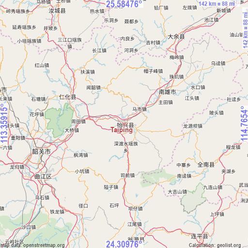
Taiping GPS coordinates[2]
24° 56' 56.076" North, 114° 3' 44.172" East
| Map corner | latitude | longitude |
|---|---|---|
| Upper-left | 25.58476°, | 113.35915° |
| Center: | 24.94891°, | 114.06227° |
| Lower-right: | 24.30976°, | 114.7654° |
| Map W x H: | 141.8×141.8 km | = 88.1×88.1mi |
| max Lat: | 53.31946° ⇑86.6% North |
| Taiping: | 24.94891° |
| min Lat: | ⇓13.4% South 18.22056° |
| min Long | Taiping | max Long |
| 75.07348° | 114.06227° | 134.28917° |
| W 49.1%⇐ | ⇒50.9% E |
Elevation
Elevation of Taiping is 108 m = 354 ft, and this is 376.8 m = 1236 ft below average elevation for this country.
| Max E: |
5622 m = 18445 ft | 58.5% |
| Avg. | 484.8 m = 1591 ft | |
| Taiping | 108 m = 354 ft | |
Min E: |
-3 m = -10 ft | 41.5% |
See also: China elevation on elevation.city.
Geographical zone
Taiping is located in North temperate zone (between Tropic of Cancer and the Arctic Circle). Distance of this Northern Tropic circle is 168.1 km =104.5 mi to South.| Distance of | km | miles | from Taiping |
|---|---|---|---|
| North Pole | 7233 | 4494.4 | to North |
| Arctic Circle | 4627.1 | 2875.1 | to North |
| Tropic Cancer | 168.1 | 104.5 | to South |
| Equator | 2774.1 | 1723.7 | to South |


Nearby cities:
15 places around Taiping: (largest is in red/bold)
• Baishun
27.1 km =16.8 mi,  352°
352°
• Cangshi
24.8 km =15.4 mi,  35°
35°
• Chengjiang
27.8 km =17.3 mi,  97°
97°
• Chengnan
2.4 km =1.5 mi,  197°
197°
• Dungang
7.7 km =4.8 mi,  116°
116°
• Gushi
22.2 km =13.8 mi,  57°
57°
• Huangkeng
27.4 km =17 mi,  296°
296°
• Luoba
17.5 km =10.9 mi, 121°
• Mashi
12.4 km =7.7 mi, 43°
• Shendushui
14.6 km =9.1 mi,  169°
169°
• Shensuo
9.2 km =5.7 mi,  250°
250°
• Shixing
0.4 km =0.2 mi, 102°
• Wenshao
27.8 km =17.3 mi,  319°
319°
• Zhoutian
25.6 km =15.9 mi,  274°
274°
• Zhutian
26.9 km =16.7 mi, 61°
Sources, notices
• [Note1] Compared only with cities in China existing in our database
• [Src1] Map data: © OpenStreetMap contributors (CC-BY-SA)
• [Src2] Other city data from geonames.org with taken over terms of usage.
• [Src3] Geographical zone / Annual Mean Temperature by Robert A. Rohde @ Wikipedia
