Mashi geodata
Mashi (Guangdong) is a seat of a fourth-order administrative division; located in China in Asia/Shanghai (GMT+8) time zone. In our database, there are 1268 cities with bigger population. Compared to other cities in China, 86.2% of cities are located further ↑North; 50.4% of cities are located further →East and 57.5% of cities have higher elevation than Mashi. Note1


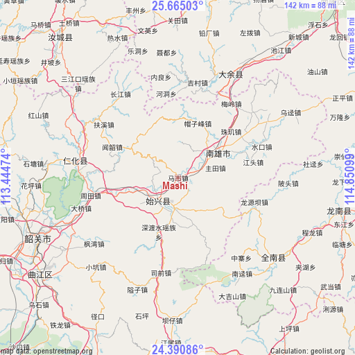
Mashi GPS coordinates[2]
25° 1' 46.56" North, 114° 8' 52.296" East
| Map corner | latitude | longitude |
|---|---|---|
| Upper-left | 25.66503°, | 113.44474° |
| Center: | 25.0296°, | 114.14786° |
| Lower-right: | 24.39086°, | 114.85099° |
| Map W x H: | 141.7×141.7 km | = 88×88mi |
| max Lat: | 53.31946° ⇑86.2% North |
| Mashi: | 25.0296° |
| min Lat: | ⇓13.8% South 18.22056° |
| min Long | Mashi | max Long |
| 75.07348° | 114.14786° | 134.28917° |
| W 49.6%⇐ | ⇒50.4% E |
Elevation
Elevation of Mashi is 114 m = 374 ft, and this is 370.8 m = 1217 ft below average elevation for this country.
| Max E: |
5622 m = 18445 ft | 57.5% |
| Avg. | 484.8 m = 1591 ft | |
| Mashi | 114 m = 374 ft | |
Min E: |
-3 m = -10 ft | 42.5% |
See also: China elevation on elevation.city.
Geographical zone
Mashi is located in North temperate zone (between Tropic of Cancer and the Arctic Circle). Distance of this Northern Tropic circle is 177.1 km =110 mi to South.| Distance of | km | miles | from Mashi |
|---|---|---|---|
| North Pole | 7224 | 4488.8 | to North |
| Arctic Circle | 4618.1 | 2869.6 | to North |
| Tropic Cancer | 177.1 | 110 | to South |
| Equator | 2783 | 1729.3 | to South |


Nearby cities:
15 places around Mashi: (largest is in red/bold)
• Baishun
21.7 km =13.5 mi,  325°
325°
• Cangshi
12.6 km =7.8 mi,  26°
26°
• Chengjiang
22.6 km =14 mi,  123°
123°
• Chengnan
14.6 km =9.1 mi,  219°
219°
• Dungang
12.5 km =7.8 mi,  188°
188°
• Gushi
10.5 km =6.5 mi,  73°
73°
• Lanhe
22.8 km =14.2 mi,  358°
358°
• Luoba
19.2 km =11.9 mi,  160°
160°
• Maozifeng
23.1 km =14.4 mi,  19°
19°
• Quan’an
15.8 km =9.8 mi,  45°
45°
• Shensuo
21.1 km =13.1 mi,  235°
235°
• Shixing
12.3 km =7.6 mi, 222°
• Taiping
12.4 km =7.7 mi, 223°
• Xiongzhou
18.1 km =11.2 mi,  57°
57°
• Zhutian
15.4 km =9.6 mi,  75°
75°
Sources, notices
• [Note1] Compared only with cities in China existing in our database
• [Src1] Map data: © OpenStreetMap contributors (CC-BY-SA)
• [Src2] Other city data from geonames.org with taken over terms of usage.
• [Src3] Geographical zone / Annual Mean Temperature by Robert A. Rohde @ Wikipedia
