Baishun geodata
Baishun (Guangdong) is a seat of a fourth-order administrative division; located in China in Asia/Shanghai (GMT+8) time zone. In our database, there are 1268 cities with bigger population. Compared to other cities in China, 85.6% of cities are located further ↑North; 51.2% of cities are located further →East and 77.4% of cities have lower elevation than Baishun. Note1


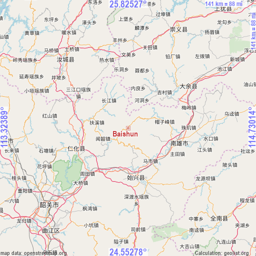
Baishun GPS coordinates[2]
25° 11' 26.484" North, 114° 1' 37.236" East
| Map corner | latitude | longitude |
|---|---|---|
| Upper-left | 25.82527°, | 113.32389° |
| Center: | 25.19069°, | 114.02701° |
| Lower-right: | 24.55278°, | 114.73014° |
| Map W x H: | 141.5×141.5 km | = 87.9×87.9mi |
| max Lat: | 53.31946° ⇑85.6% North |
| Baishun: | 25.19069° |
| min Lat: | ⇓14.4% South 18.22056° |
| min Long | Baishun | max Long |
| 75.07348° | 114.02701° | 134.28917° |
| W 48.8%⇐ | ⇒51.2% E |
Elevation
Elevation of Baishun is 587 m = 1926 ft, and this is 102.2 m = 335 ft above average elevation for this country.
| Max E: |
5622 m = 18445 ft | 22.6% |
| Baishun | 587 m 1926 ft | |
| Avg. | 484.8 m = 1591 ft | |
Min E: |
-3 m = -10 ft | 77.4% |
See also: China elevation on elevation.city.
Geographical zone
Baishun is located in North temperate zone (between Tropic of Cancer and the Arctic Circle). Distance of this Northern Tropic circle is 195 km =121.2 mi to South.| Distance of | km | miles | from Baishun |
|---|---|---|---|
| North Pole | 7206.1 | 4477.7 | to North |
| Arctic Circle | 4600.2 | 2858.4 | to North |
| Tropic Cancer | 195 | 121.2 | to South |
| Equator | 2800.9 | 1740.4 | to South |


Nearby cities:
15 places around Baishun: (largest is in red/bold)
• Cangshi
19 km =11.8 mi,  110°
110°
• Changjiang
18.2 km =11.3 mi,  326°
326°
• Chengnan
29.3 km =18.2 mi,  174°
174°
• Fuxi
17.3 km =10.7 mi,  279°
279°
• Gushi
26.8 km =16.7 mi,  123°
123°
• Huangkeng
25.6 km =15.9 mi,  234°
234°
• Lanhe
12.4 km =7.7 mi,  67°
67°
• Maozifeng
20.4 km =12.7 mi,  79°
79°
• Mashi
21.7 km =13.5 mi,  145°
145°
• Quan’an
24.3 km =15.1 mi, 106°
• Shixing
27.2 km =16.9 mi, 171°
• Taiping
27.1 km =16.8 mi, 172°
• Wenshao
15.4 km =9.6 mi,  248°
248°
• Xiongzhou
28.7 km =17.8 mi, 106°
• Zhutian
30.4 km =18.9 mi, 117°
Sources, notices
• [Note1] Compared only with cities in China existing in our database
• [Src1] Map data: © OpenStreetMap contributors (CC-BY-SA)
• [Src2] Other city data from geonames.org with taken over terms of usage.
• [Src3] Geographical zone / Annual Mean Temperature by Robert A. Rohde @ Wikipedia
