Xintian geodata
Xintian (Guangdong) is a seat of a fourth-order administrative division; located in China in Asia/Shanghai (GMT+8) time zone. In our database, there are 1268 cities with bigger population. Compared to other cities in China, 88.6% of cities are located further ↑North; 57.1% of cities are located further ←West and 70.2% of cities have lower elevation than Xintian. Note1


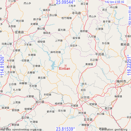
Xintian GPS coordinates[2]
24° 27' 25.344" North, 115° 31' 9.768" East
| Map corner | latitude | longitude |
|---|---|---|
| Upper-left | 25.09544°, | 114.81626° |
| Center: | 24.45704°, | 115.51938° |
| Lower-right: | 23.81539°, | 116.22251° |
| Map W x H: | 142.3×142.3 km | = 88.4×88.4mi |
| max Lat: | 53.31946° ⇑88.6% North |
| Xintian: | 24.45704° |
| min Lat: | ⇓11.4% South 18.22056° |
| min Long | Xintian | max Long |
| 75.07348° | 115.51938° | 134.28917° |
| W 57.1%⇐ | ⇒42.9% E |
Elevation
Elevation of Xintian is 416 m = 1365 ft, and this is 68.8 m = 226 ft below average elevation for this country.
| Max E: |
5622 m = 18445 ft | 29.8% |
| Avg. | 484.8 m = 1591 ft | |
| Xintian | 416 m = 1365 ft | |
Min E: |
-3 m = -10 ft | 70.2% |
See also: China elevation on elevation.city.
Geographical zone
Xintian is located in North temperate zone (between Tropic of Cancer and the Arctic Circle). Distance of this Northern Tropic circle is 113.4 km =70.5 mi to South.| Distance of | km | miles | from Xintian |
|---|---|---|---|
| North Pole | 7287.7 | 4528.4 | to North |
| Arctic Circle | 4681.8 | 2909.1 | to North |
| Tropic Cancer | 113.4 | 70.5 | to South |
| Equator | 2719.4 | 1689.8 | to South |


Nearby cities:
15 places around Xintian: (largest is in red/bold)
• Chetian
23.7 km =14.7 mi,  263°
263°
• Chiguang
12 km =7.5 mi,  228°
228°
• Daping
15.6 km =9.7 mi,  157°
157°
• Gangbei
22.2 km =13.8 mi,  125°
125°
• Huangbei
22.7 km =14.1 mi,  102°
102°
• Huilong
9.7 km =6 mi,  176°
176°
• Lizui
22.9 km =14.2 mi,  236°
236°
• Longmu
23.1 km =14.4 mi,  201°
201°
• Longting
23.7 km =14.7 mi,  21°
21°
• Luofu
9.9 km =6.2 mi,  37°
37°
• Luogang
11.7 km =7.3 mi,  106°
106°
• Mabugang
18.1 km =11.2 mi,  324°
324°
• Pingyang
21.1 km =13.1 mi, 133°
• Tianxin
21.6 km =13.4 mi,  187°
187°
• Yanzhen
7.9 km =4.9 mi,  297°
297°
Sources, notices
• [Note1] Compared only with cities in China existing in our database
• [Src1] Map data: © OpenStreetMap contributors (CC-BY-SA)
• [Src2] Other city data from geonames.org with taken over terms of usage.
• [Src3] Geographical zone / Annual Mean Temperature by Robert A. Rohde @ Wikipedia
