Jinzhuang geodata
Jinzhuang (Guangdong) is a seat of a fourth-order administrative division; located in China in Asia/Shanghai (GMT+8) time zone. In our database, there are 1268 cities with bigger population. Compared to other cities in China, 90.9% of cities are located further ↑North; 63.3% of cities are located further →East and 71% of cities have higher elevation than Jinzhuang. Note1


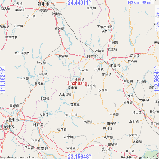
Jinzhuang GPS coordinates[2]
23° 48' 5.004" North, 111° 51' 55.008" East
| Map corner | latitude | longitude |
|---|---|---|
| Upper-left | 24.44311°, | 111.16216° |
| Center: | 23.80139°, | 111.86528° |
| Lower-right: | 23.15648°, | 112.56841° |
| Map W x H: | 143.1×143.1 km | = 88.9×88.9mi |
| max Lat: | 53.31946° ⇑90.9% North |
| Jinzhuang: | 23.80139° |
| min Lat: | ⇓9.1% South 18.22056° |
| min Long | Jinzhuang | max Long |
| 75.07348° | 111.86528° | 134.28917° |
| W 36.7%⇐ | ⇒63.3% E |
Elevation
Elevation of Jinzhuang is 48 m = 157 ft, and this is 436.8 m = 1433 ft below average elevation for this country.
| Max E: |
5622 m = 18445 ft | 71% |
| Avg. | 484.8 m = 1591 ft | |
| Jinzhuang | 48 m = 157 ft | |
Min E: |
-3 m = -10 ft | 29% |
See also: China elevation on elevation.city.
Geographical zone
Jinzhuang is located in North temperate zone (between Tropic of Cancer and the Arctic Circle). Distance of this Northern Tropic circle is 40.5 km =25.2 mi to South.| Distance of | km | miles | from Jinzhuang |
|---|---|---|---|
| North Pole | 7360.6 | 4573.7 | to North |
| Arctic Circle | 4754.7 | 2954.4 | to North |
| Tropic Cancer | 40.5 | 25.2 | to South |
| Equator | 2646.5 | 1644.5 | to South |


Nearby cities:
15 places around Jinzhuang: (largest is in red/bold)
• Chang’an
9.4 km =5.8 mi,  17°
17°
• Dagang
19.6 km =12.2 mi,  62°
62°
• Dayukou
18.5 km =11.5 mi,  225°
225°
• Duping
25.6 km =15.9 mi, 225°
• Ganping
23.3 km =14.5 mi,  27°
27°
• Lanzhong
30.6 km =19 mi, 15°
• Lengkeng
31.3 km =19.4 mi, 34°
• Liandu
24 km =14.9 mi,  190°
190°
• Liangcun
22.4 km =13.9 mi,  42°
42°
• Maning
27.4 km =17 mi, 21°
• Nanfeng
10.8 km =6.7 mi,  219°
219°
• Qiaotou
12.4 km =7.7 mi,  120°
120°
• Shidong
28.8 km =17.9 mi,  134°
134°
• Yonggu
22.8 km =14.2 mi,  114°
114°
• Zhagang
24.2 km =15 mi,  81°
81°
Sources, notices
• [Note1] Compared only with cities in China existing in our database
• [Src1] Map data: © OpenStreetMap contributors (CC-BY-SA)
• [Src2] Other city data from geonames.org with taken over terms of usage.
• [Src3] Geographical zone / Annual Mean Temperature by Robert A. Rohde @ Wikipedia
